
Is It Safe to Visit Nepal After the Flood
Summary: Is It Safe to Visit Nepal After the Flood? Yes, Nepal is safe to visit after the August 2026 floods, provided your route avoids the affected areas. Kathmandu, Pokhara, Everest, Annapurna and Manaslu remain open and are operating normally. However, the Langtang Region, Trishuli River and Bhotekoshi corridor remain closed due to damaged access routes. Travellers should still check current road conditions before departure and follow the advice of their own government throughout their trip.
Nepal Travel After the Flood: What Travellers Need to Know
Most of Nepal is open for travel right now. The August 2026 flash floods tore through the Bhote Koshi and Trishuli river systems, but the damage stayed within the Rasuwa district corridor. Kathmandu, Pokhara, Everest, Annapurna and Manaslu sit on separate river systems entirely, and all of them are running to their normal schedule. In short, Nepal is safe to travel after the flood, provided your trip stays clear of that Rasuwa corridor.
Nepal is not affected uniformly, and that matters more than any single headline. A trekker bound for the Khumbu faces a completely different picture than one who booked a Langtang teahouse trek, even though both itineraries fall under the same country and the same disaster news cycle. As you weigh your travel plans, you will need to think through destination, timing, transportation, weather, accommodation, and travel insurance, and each of those choices looks different depending on whether your route touches the flood zone or sits nowhere near it.
This guide walks through which areas in Nepal are currently accessible, where travellers should slow down or postpone, how the floods have touched roads and trekking routes, what to check before you fly out, and how to travel respectfully while affected communities recover. By the end, you should know whether Nepal still fits your plans, what precautions to take, and how to make a calmer, better-informed call than a scary headline alone would give you. Nepal Hiking Adventure can also help you assess current routes and plan your trip accordingly.
Is It Safe to Travel to Nepal Right Now? (Quick Answer)
| Region | Status | Traveller Action |
| Kathmandu, Pokhara, Everest, Annapurna, Manaslu | Operating normally | Proceed with standard planning. |
| Rasuwa district (Timure, Syabrubesi, Rasuwagadhi) | Closed, active recovery zone | Avoid entirely. |
| Langtang, Gosaikunda, Tamang Heritage Trail | Access routes damaged | Postpone or reroute. |
| Nuwakot, Dhading, Gorkha, Tanahun, Chitwan | Downstream, partially affected | Confirm specific lodge or area. |
That is the core question every reader lands here with, so here is the direct version. Most of Nepal, including the country’s biggest tourism draws, escaped the August 2026 flooding entirely, since Kathmandu, Pokhara, Everest, Annapurna, and Manaslu all sit on river systems separate from the disaster corridor. Tribhuvan International Airport has kept handling both domestic and international flights throughout the response effort, which tells you a great deal about how contained the damage actually is.
The one area you should avoid outright right now is the Rasuwagadhi-Timure-Syabrubesi corridor in Rasuwa, including the Nepal-China border crossing there, in line with the current US State Department advisory. Everywhere else on the standard trekking map remains open, though monsoon-season caution still applies country-wide regardless of the flood.
What Happened During the August 2026 Nepal Floods
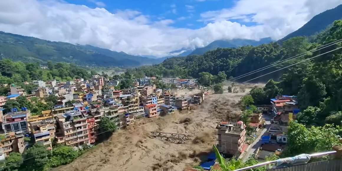
The disaster began on August 26, when major flash flooding and mudslides tore through the Bhote Koshi and Trishuli river systems, striking Rasuwa, Nuwakot, Dhading, Gorkha, Tanahun, Nawalparasi, and Chitwan in quick succession. Water levels on the Trishuli River reportedly climbed by as much as 9 metres in roughly 30 minutes, which is closer to a wall of water than a rising river.
Early reporting points to a glacial or ice-rock collapse near Langtang Lirung and the upper Lhende River system as the likely trigger, although the exact chain of causes remains under scientific review. Meanwhile, a barrier lake formed near the border between Nepal and China once debris blocked the river, and it began overflowing on August 28.
Key facts, at a glance:
- Nepal’s Department of Hydrology and Meteorology later said the immediate burst risk had eased, though officials flagged a slight rise in water flow again on August 30.
- China reported separate flooding on the Tibet side of the border, with its own casualty and missing-person figures. Anyone who also plans to travel to Tibet on the same trip should check China’s advisories independently, since the two sides of the border are being tracked separately.
- The event is now widely described as one of the more devastating flash floods to hit this river corridor in recent memory.
This was a genuine natural disaster with a fast, violent onset, and understanding that timeline matters because it explains why the affected zone is narrow rather than nationwide. The flooding followed a specific river corridor. It did not sweep across Nepal and Tibet as a whole, and that single fact reshapes almost everything else in this guide.

Which Areas of Nepal Were Directly Affected by the Floods
| Region | Flood Impact | Current Status | Traveller Action |
| Rasuwa (Timure, Syabrubesi, Rasuwagadhi) | Direct, severe | Recovery zone, access restricted | Avoid |
| Nuwakot, Dhading, Gorkha, Tanahun, Nawalparasi | Downstream, partial | Reopening in stages | Check locally. |
| Chitwan | Partial, district-wide varies | Mostly operating | Confirm specific lodge |
| Kathmandu Valley, Pokhara, Everest, Annapurna, Manaslu, Lumbini, Nagarkot | Not in the flood path | Normal operations | No special caution needed |
Rasuwa district took the most direct hit, particularly Timure, Syabrubesi, and Rasuwagadhi, where transport and communications infrastructure have been severely damaged. Further downstream, Nuwakot, Dhading, Gorkha, Tanahun, Nawalparasi, and Chitwan absorbed a lighter but still meaningful share of the impact. If you need to travel through any of these downstream districts for reasons unrelated to tourism, confirm current access with local authorities before you set out.
On the other hand, Nepal’s government has declared 15 municipalities across these areas as disaster crisis-affected zones for a three-month period, according to the World Health Organization’s regional office. Kathmandu Valley, Pokhara, Everest, Annapurna, Manaslu, Lumbini, and Nagarkot, meanwhile, were never in the flood’s path in the first place, since they draw from entirely separate river systems than the Bhote Koshi and Trishuli corridor.
Nepal Floods 2026: Death Toll, Missing Persons, and Rescue Update
Last updated: September 6, 2026
| Category | Nepal | Tibet (China) |
| Confirmed Deaths | 1,344 (including 843 fully recovered bodies and 501 retrieved amputated remains) | 21 |
| Missing Persons | 4,898 (including 590 foreign nationals) | 541 (including 104 Nepali citizens) |
| Injured | 2,301+ | Not explicitly aggregated |
| Rescued to Date | Nearly 13,100 (via multi-agency operations and tunnel extractions) | Ongoing airdrop and ground rescues |
According to the latest government figures, the flash floods along the Nepal-Tibet border have now claimed at least 1,344 lives in Nepal, with 4,898 people still missing across the country. Together, the floods in Nepal and Tibet have touched roughly 1.6 million people in total, and recovery crews are still fighting thick mud, heavy debris, and damaged infrastructure days after the initial glacial collapse on August 26.
Among the missing foreign nationals in Nepal and Tibet combined are 288 Indian nationals, 75 Americans, 53 Ukrainians, 51 Malaysians, 38 Australians, and 33 UK nationals. Many of the missing locals, meanwhile, are hydropower workers still trapped inside flooded tunnels and underground facilities along the Bhotekoshi and Trishuli river corridors. Because only about 4% of recovered bodies have been formally identified so far, grieving families in Kathmandu and Nuwakot have started holding symbolic funerals using hay and straw effigies while identification work continues.
Rescue and Relief Operations Update
- Personnel deployment: The Government of Nepal has officially declared a flood emergency across 15 municipalities, and over 22,000 security personnel from the Nepal Army, Armed Police Force, and Nepal Police are now working the ground response.
- Infrastructure and blockades: Large-scale clearing is underway, though the Mugling-Malekhu section of the Prithvi Highway remains completely blocked by severe erosion, locally described as “toe-cutting”. Power has been restored in Dhading and Nuwakot, and repair crews continue working the grid in Rasuwa.
- International aid: India has deployed an 11-member rescue team with over 6 tonnes of gear and 5 tonnes of medicines. China has reopened highway G216 to the Gyirong crossing, letting heavy machinery reach the disaster zones instead of relying on airdrops. Qatar has flown in emergency aid for roughly 52,000 affected people.
- Early-warning system: Nepal is moving ahead with plans to rebuild a landslide early-warning system in Timure, Rasuwa, using satellite links, cameras, and seismic sensors to catch future glacier surges before they reach communities downstream.
How the Response Is Coordinated
The Government of Nepal has organised 15 sectoral task teams under its disaster management command post, including:
- Missing persons and family assistance, tasked with identifying victims, managing recovered bodies, and registering missing tourists, trekkers, and locals
- Hydropower rescue, focused on deep-tunnel drilling and controlled site expansions at Trishuli 3A, Trishuli 3B, Haku Besi, and Chilime
- Logistics and distribution, running a fleet of 34 trucks, 35 jeeps, and at least 16 operational rescue helicopters
If you are travelling to any part of the affected area for reasons unrelated to tourism, follow the instructions of local authorities and coordinate through official channels such as the Ministry of Foreign Affairs, rather than attempting an independent search or recovery effort.

Official Travel Advice: What the US, UK, and Nepal Governments Say
Three governments have each published their own current Nepal travel advice this week, and it is worth reading all three before you decide anything.
United States: The State Department’s current travel advice instructs travellers not to enter the Rasuwagadhi-Timure-Syabrubesi corridor or the Nepal-China border crossing there and specifically warns against entering the disaster area independently to search for missing persons.
United Kingdom: The Foreign, Commonwealth and Development Office has not issued a blanket warning to avoid non-essential travel to Nepal as a whole. Its guidance instead focuses on the flood-hit districts and the general monsoon risk, and it notes conditions in the worst-hit areas can change rapidly. British nationals who need assistance from the UK government should contact the FCDO’s consular team before making independent travel decisions in Nepal.
Nepal: Local officials continue to publish district-level updates, and the advice of the Nepalese government remains broadly consistent with the US and UK positions, namely that Rasuwa’s core disaster zone is off limits while the rest of the country functions normally.
The FCDO also recommends travel insurance that covers your specific itinerary and planned activities, plus emergency costs, which is sound advice whether or not a flood is in the news. Governments are generally advising registration with local embassy programmes, such as the US STEP system, so that travellers can receive real-time alerts and stay alert to the changing situation in Nepal, rather than relying on a single advisory checked once before departure.
Whichever country you are from, the safest approach is to check current government travel advice for Nepal directly from your own government’s official page before departure, rather than relying on secondhand summaries. Guidance can shift within days as road conditions and affected-area status change, so a page checked last week may already be out of date.
Is Kathmandu Safe to Visit After the Floods?
Kathmandu was never in the flood’s path, and that is the short version. Tribhuvan International Airport has kept running its normal domestic and international schedule throughout the disaster response, and day-to-day tourism in the valley, including Durbar Square, Boudhanath, and Swayambhunath, has continued without disruption.
Some roads leaving the valley toward Rasuwa, Pokhara, and Chitwan did see temporary closures while crews cleared debris, and most have since reopened. Even so, it is worth building in a little flexibility, since short monsoon-season closures on roads and bridges remain possible independent of the flood itself.
After the floods, is it safe to travel to Pokhara?
Pokhara sits well outside the Bhote Koshi and Trishuli disaster corridor, and both its tourist areas and domestic flights are operating as normal. The city’s lakeside district, paragliding operators, and trekking outfitters have reported no disruption tied to the flood.
The Prithvi Highway linking Kathmandu and Pokhara runs alongside part of the Trishuli River and did see temporary closures right after the flood hit. Following a landslide on the Krishnavir section on August 30, domestic flights became the steadier option for a stretch, even though Pokhara itself remained accessible throughout, just via a slightly longer detour.
Are Nepal’s Major Trekking Regions Safe After the Floods?
Here is the direct answer for every major route: Everest, Annapurna, and Manaslu are all running on schedule, and Langtang is the one region currently closed.
Everest Region
Everest Region is safe to trek right now. The region drains into the Dudh Koshi river system, which has no connection to the Bhote Koshi flood corridor, and Lukla flights alongside the full Everest Base Camp trek route have continued on a normal schedule, aside from the routine weather delays that hit Lukla in any given season.
Annapurna Region
Annapurna Circuit treks remain unaffected. The region is fed by the Marsyangdi and Kali Gandaki rivers, entirely separate from the flood zone, and guides on the ground report the Annapurna Circuit, Annapurna Base Camp, Poon Hill trek, and Upper Mustang are all operating normally.
Manaslu Region
Manaslu is open and, if anything, busier than usual this season. The region is accessed from Arughat in Gorkha district on a different road and river system than the Bhote Koshi corridor entirely. Nepal’s Department of Tourism had issued permits for 18 Manaslu teams totalling 219 foreign climbers this season, and operators such as Seven Summit Treks confirmed their autumn Manaslu, Dhaulagiri, and eastern Nepal itinerary plans remained on schedule. Manaslu is also drawing extra interest because the China-Tibet Mountaineering Association confirmed Shishapangma and Cho Oyu will stay closed this season, which has pushed some teams to switch routes toward it instead.
Langtang Region (Currently Restricted)
Langtang National Park sits directly south of Rasuwa, and its main access point, Syabrubesi, absorbed serious damage. Closed routes currently include the Langtang Valley, Gosaikunda, the Tamang Heritage Trail, Helambu Circuit, Ruby Valley, and the overland Kailash route through Rasuwagadhi. The US Embassy’s Rasuwa flooding advisory confirms damage still prevents normal travel beyond Dhunche toward Syabrubesi, Timure, and the Langtang trails, and the Rasuwagadhi border crossing remains inaccessible for now.
Alternative Route: Sundarijal to Gosainkunda
The good news is you don’t need Rasuwa access to reach Gosainkunda. A separate route climbs out of Sundarijal, near Kathmandu, through Chisapani, Kutumsang, and Lauribina Pass (4,610m) to Gosainkunda, then back the same way to Sundarijal. This trail stays entirely within Shivapuri National Park and the southern edge of Langtang National Park, avoiding Syabrubesi, Timure, and the Rasuwagadhi border area covered by the current advisory.
Chitwan, Lumbini, and Other Lowland Destinations
Chitwan saw downstream flooding in parts of the district, so it is worth confirming your specific lodge or area rather than assuming the whole district is affected. Lumbini, meanwhile, was never named among the affected districts and has been operating normally throughout.


Should You Cancel or Postpone Your Nepal Trip?
If your itinerary does not pass through Rasuwa or the Langtang access corridor, there is currently no official reason to cancel a Nepal trip entirely. Your travel plans for Everest, Annapurna, Manaslu, Kathmandu, or Pokhara remain sound as they stand.
If your original plan included Syabrubesi, Timure, Rasuwagadhi, or the Langtang trek itself, operators are recommending postponement or a substitute region rather than pushing ahead with a pre-flood plan. One recent client had booked a Langtang teahouse trek for late September and, after speaking with her operator, rerouted to Annapurna Base Camp instead, keeping her travel dates and simply swapping the mountain.
For any Langtang booking still on the books, contact your travel agency and ask for a written, current status update on the Syabrubesi road, trailhead condition, and guide availability, rather than relying on an itinerary drafted before the flood.
How to Check the Latest Road and Trail Conditions Before You Travel
Trail condition and road conditions are not the same thing, and conflating them is the most common mistake travellers make right now. A trekking route can be physically intact while its access road remains damaged, and the reverse holds just as often.
Before departure, confirm each of the following:
- Access road status to your trailhead
- Bridge and river crossing conditions along the route
- Current on-trail conditions from a guide who has walked it this week
- Teahouse availability at your planned stops
- Weather forecast for your travel window
- Any current local authority notices for your specific district
Whatever you do, check the latest travel advice with your operator rather than trusting a static blog post. For guidance tailored to your own route, always follow the direction of guides working the trail in real time.
Nepal Travel Safety Checklist for the 2026 Monsoon Season
- Heavy monsoon rain carries an ongoing risk of further landslides and flooding on mountain roads, independent of the Rasuwa disaster entirely.
- River crossings on trekking trails can become harder to pass after heavy rain, and mountain flights to Lukla or Jomsom can see weather delays regardless of flood status.
- Nepal’s monsoon season runs roughly June through September, and ordinary seasonal risk applies across the entire country every year, flood or no flood. Visiting Nepal during the monsoon season simply calls for a bit more planning around wet trails and possible delays.
- Pack for wet trails even on routes nowhere near the disaster zone, since monsoon conditions do not respect the flood’s boundary lines.
Emergency Contacts and Official Resources for Nepal
| Resource | Contact | Use For |
| Nepal Tourist Police | 1144 (toll-free) | Tourist safety and assistance |
| General police | 100 | General emergencies |
| US Embassy Rasuwa advisory | Official embassy page | Road closures, US citizen reporting |
| Nepal government rescue portal | Official channel | Reporting disaster-affected persons |
| Nepal Tourism Board | Coordinating with authorities | Search, rescue, and tourist welfare checks |
Keep the hotline number saved before you fly. Register with your embassy’s travel programme so you can get the latest travel alerts sent straight to your phone, rather than checking manually mid-trip. The Nepal Tourism Board has said it is actively coordinating with relevant authorities on search and rescue and on welfare checks for travellers currently in the country.
Final Verdict: Is It Safe to Visit Nepal After the Flood?
Is It Safe to Visit Nepal After the Flood? Nepal’s short answer has not changed through this whole guide. Yes, it is safe to visit, provided your route avoids Rasuwa and the Langtang access corridor. The flooding was severe, and the human cost is real, but it followed one river corridor rather than sweeping across the country, and the situation for Kathmandu, Pokhara, Everest, Annapurna, and Manaslu has stayed essentially unchanged throughout.
This guide fits travellers whose itinerary already sits outside the affected zone just as well as it fits anyone currently holding a Langtang booking that now needs to change. If your plans touch Rasuwa or Langtang directly, postponement or a reroute to Annapurna or Manaslu makes more sense than pushing ahead on outdated information, and your operator should be willing to say so plainly.
Before you finalise anything, confirm current conditions with a local operator who has updated its advice this week rather than last month, and travel with a licensed guide regardless of region. The regions that remain open are genuinely open, so plan, compare, and travel to Nepal with the same confidence you would have had before the headlines, just with slightly better information than most travellers bring with them. Nepal Hiking Adventure can help you check current conditions and plan your route. Contact us before you travel for the latest local guidance.

Is It Safe to Visit Nepal After the Flood? FAQs
Is Nepal Safe to Visit After the August 2026 Flood?
Yes, most of the country is safe to visit, with the exception of the Rasuwa disaster corridor. Kathmandu, Pokhara, Everest, Annapurna, and Manaslu were never in the flood’s path.
Is Kathmandu Safe After the Rasuwa Flood?
Yes, Kathmandu was not affected by the flood and continues normal operations. The airport, city sites, and onwards road links have all stayed open, aside from brief debris-clearing closures.
Is Pokhara Affected by the Rasuwa Flood?
No, Pokhara sits outside the flood corridor entirely. Domestic flights and the Prithvi Highway saw brief disruption, but the city itself was untouched.
Is the Everest Base Camp Trek Affected by the Floods?
No, the Everest region drains into a separate river system from the flood zone. Lukla flights and the full trek route have continued on a normal seasonal schedule.
Is the Annapurna Circuit Safe to Trek Right Now?
Yes, Annapurna treks are running as normal this season. The region’s rivers are unconnected to the Bhote Koshi and Trishuli flood corridor.
Is Langtang Trek Safe After the Flood?
No, Langtang remains closed while recovery continues. Syabrubesi and the surrounding trailheads sustained direct, serious damage.
Are Roads in Nepal Safe During Monsoon?
Roads carry ordinary monsoon risk independent of the flood, including occasional landslides. Always check the latest road status before any overland journey.
Are Flights to Nepal Operating Normally?
Yes, Tribhuvan International Airport has run a normal schedule throughout the disaster response. Domestic flights to Lukla and Pokhara continue on their usual seasonal pattern.
Do I Need Travel Insurance for Nepal?
Yes, and it should specifically cover high-altitude trekking and helicopter evacuation. Standard policies frequently exclude those above a set elevation.
What Do the US and UK Governments Say About Travel to Nepal?
Both advise avoiding the Rasuwa disaster corridor while treating the rest of the country as open. Neither has issued a blanket warning against travel to Nepal as a whole.
Where Can I Find Official Nepal Travel Updates?
The Nepal Tourism Board, your national embassy, and the US Embassy’s Rasuwa advisory page all publish current updates. Check these directly rather than relying on secondhand summaries.


Our History in Service Excellence


