
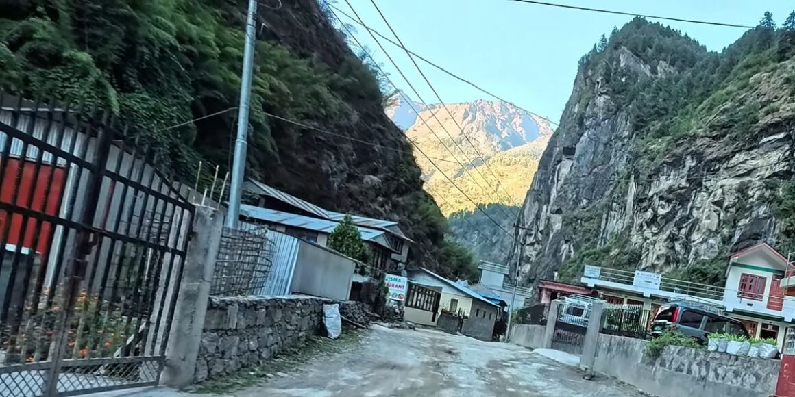
Dharapani Village
Summary: Dharapani Village sits at 1,860m in Manang district, marking the exact junction where the Manaslu Circuit ends and the Annapurna Circuit begins. The checkpost here verifies permits from both restricted zones, requiring original documents from trekkers transitioning between conservation areas. Reached via a 4-6 hour jeep ride from Besisahar, Dharapani offers basic teahouse accommodation and serves as a key rest stop before the climb toward Chame.
Understanding Dharapani Village
Dharapani Village sits at one of the most consequential crossroads in Himalayan trekking. Positioned at roughly 1,860 metres in the Manang district of northern Nepal, it marks the point where the Manaslu Circuit and the Annapurna Circuit physically meet. Most trekkers pass through without fully registering what that means for their route, their permits, or their acclimatisation schedule.
That oversight is worth correcting. The significance of Dharapani is not simply geographic. It is logistical. The decisions made here, whether to continue along the Annapurna Circuit trek or turn back toward Besisahar, shape the entire character of a multi-week expedition. Understanding this village before you arrive saves time, reduces confusion at the checkpost, and gives your itinerary a clearer backbone.
This guide from Nepal Hiking Adventure covers everything you need. From the location of Dharapani and how to get there to accommodation, permits, seasonal conditions, and where it fits inside a full trek itinerary. Whether you are combining both circuits or simply passing through, the information here is practical, ground-level, and ready to use.


Where Is Dharapani Village Located
Dharapani is situated in the upper Marsyangdi River valley in the Manang district of Gandaki Province, northern Nepal. It lies at approximately 1,860 metres above sea level, where the valley narrows and the trail begins its serious climb toward higher terrain.
Geographic Position in the Annapurna Region
- Dharapani sits at the northern boundary of the Annapurna region, administratively inside Manang District
- It lies along the Marsyangdi river, where the river valley’s corridor transitions from subtropical broadleaf forest to drier alpine scrub
- The village is roughly 145 km by road from Kathmandu, though road conditions and trail conditions vary by season
- To the south lies Jagat and the deeper gorge of the Manaslu conservation area; to the north, the valley opens toward Chame and eventually Manang
Elevation and Landscape Overview
| Feature | Detail |
| Elevation | Approximately 1,860 m (6,102 ft) |
| Coordinates | Approx. 28.49° N latitude and 84.5° E longitude |
| River | Marsyangdi River |
| District | Manang District, Gandaki Province |
| Nearest Major Town | Besisahar (approx. 4 to 5 hrs by jeep) |
| Terrain Type | Mid-mountain river valley |
The landscape around Dharapani is notably varied. Terraced fields step down the hillsides to the east, while prayer flags mark the ridge lines above the village. The Himalayas frame the northern skyline, giving the village genuine scenic beauty even by the standards of a region known for dramatic terrain.

Administrative and Trail Significance
- Dharapani is the last major village before the trail formally enters the Annapurna Conservation Area Project from the Manaslu side
- It functions, therefore, as a permit transition point between two distinct trekking zones
- The checkpost here verifies permits from both the Manaslu region and the Annapurna Conservation Area
- Consequently, this administrative role makes it a point for trekkers that carries real logistical weight, not just geographic interest
Dharapani as a Key Trekking Junction
Dharapani is one of very few places in the Himalayas where two major long-distance routes physically converge. That convergence is precisely what makes it genuinely important to understand before you arrive.
Gateway Between Manaslu Circuit and Annapurna Circuit
- Dharapani serves as the official exit point of the Manaslu Circuit trek, connecting directly with the Annapurna Circuit
- From here, trekkers on the Manaslu circuit can transition directly onto the Annapurna Circuit without backtracking to the roadhead
- The combined route, entering from Jagat to Dharapani via the Manaslu side and continuing toward Chame on the Annapurna side, is one of the most complete high-altitude traverses available in Nepal
- This makes Dharapani a genuine gateway for trekkers, linking two UNESCO-recognised conservation areas
Transition Point After Restricted Area Treks
- The Manaslu restricted area ends at Bhimthang, with permit verification at the Dharapani checkpoint
- At Dharapani, that restriction ends. The trail from here into the Annapurna Conservation Area operates under a different permit framework
- Many trekkers find the checkpost process here straightforward, though it is still worth preparing for. Have all documents accessible before reaching the post office
Trekking Routes Connected to Dharapani
Dharapani connects directly to some of the most-walked trekking routes in Nepal. Understanding each link helps you plan a route that matches your timeline and fitness level.
Manaslu Circuit Trek Route Link
- The classic Manaslu circuit trek runs from Kathmandu to Soti Khola, then through Machha Khola, Jagat, Deng, Namrung, Lho, Samagaun, Samdo, Larke La Pass, Bhimthang, and finally to Dharapani
- The full circuit takes 14 to 18 days, depending on pace and acclimatisation stops
- Dharapani is the natural endpoint. From here, most groups descend to Besisahar or continue onto the Annapurna side. Notably, Dharapani lies at the precise point where the restricted Manaslu zone gives way to open trekking, which is why it functions as the final stop on the Manaslu before the route transitions
Annapurna Circuit Trek Route Link
- The Annapurna circuit trek traditionally starts at Besisahar, follows the Marsyangdi Valley north through Dharapani, continues to Chame, Upper Pisang, Manang, Thorong La Pass, and descends to Muktinath and Jomsom
- Dharapani sits in the early-to-mid section of this circuit trek, typically reached on day 2 from Kathmandu
- Kathmandu to Dharapani is a full-day drive, and for many trekkers, the Annapurna Circuit trek begins from Dharapani.
- It is, moreover, a well-supplied stop with enough accommodation to rest before the push to Chame
Popular Trekking Itineraries Passing Dharapani
| Itinerary | Duration | Dharapani Role |
| Manaslu Circuit only | 14 to 18 days | Final trek destination before exit |
| Annapurna Circuit only | 12 to 16 days | Starting point and first overnight stop |
| Manaslu and Annapurna combined | 20 to 26 days | Central transition point |
| Short Annapurna section | 6 to 8 days | Possible turnaround |
Alternative Trails and Side Routes
- A rough trail runs south from Dharapani toward Tal and the lower Marsyangdi gorge, useful for trekkers exiting toward Besisahar on foot
- In addition, shorter walks around the village toward the forested ridges above offer good views without significant altitude gain
- Dharapani also connects to local herding paths used by Gurung and Tibetan-influenced communities moving livestock between seasonal pastures

What to Expect in Dharapani Village
Dharapani is a charming village by the honest standards of a working Himalayan transit stop. It is not polished or built for tourism. It is a real community that also happens to sit on one of the busiest trek junctions in the region.
Village Layout and First Impressions
- The village is situated along a single major route, with tiny businesses and teahouses on either side
- Stone and timber construction dominates. Buildings are compact, practical, and built to handle long winters
- Prayer flags are visible across rooftops and on the ridge above the village
- The setting is framed by steep valley walls and, on clear days, by the snow line of the Himalayas to the north
Local Culture and Ethnic Communities
- Dharapani is home to a mixed community with Gurung, Tibetan-influenced, and Magar households
- Local festivals, particularly around the lunar calendar, bring genuine colour to what is otherwise a quiet settlement
- Terraced fields below the village are actively farmed, primarily with millet, buckwheat, and potato crops at this elevation
Daily Life in a Himalayan Transit Village
- Most economic activity centres on trekkers passing through. Teahouse owners, porters, and small shop traders form the commercial backbone
- Water comes from piped spring sources. Electricity is available but unreliable in poor weather
- The pace is slow. Locals rise early, tend fields and livestock, and turn in well before most trekkers would consider it evening
Accommodation and Food in Dharapani
Facilities in Dharapani are functional rather than comfortable by urban standards. Nevertheless, for a trek at this level, they are adequate and improving year on year.
Teahouse Standards and Availability
- Teahouses in Dharapani offer simple rooms with a bed, blanket, and basic pillow
- Attached bathrooms are available in some lodges, though shared facilities remain common
- Hot water is either bucket-based or solar-heated, depending on the season and weather
- Booking ahead is not strictly necessary outside peak season, though it is wise during October and April
Typical Food Menu and Pricing Range
| Item | Approximate Cost (NPR) |
| Dal bhat (unlimited refills) | 500 to 900 |
| Tibetan bread with jam | 250 to 350 |
| Noodle soup | 300 to 450 |
| Egg breakfast | 250 to 350 |
| Tea or coffee | 100 to 200 |
Dal bhat remains the most reliable and nutritious option at this altitude. Portions are generous, and refills are standard. Tibetan bread, fried and served warm, is a common breakfast alongside tea.
Comfort Level Compared to Other Stops
| Stop | Room Quality | Food Variety | Hot Shower |
| Besisahar | Good | Wide | Yes |
| Dharapani | Basic | Moderate | Bucket or Solar |
| Chame | Moderate | Good | Mostly yes |
| Manang | Good | Wide | Yes |
Dharapani sits comfortably in the middle of the comfort spectrum for this stretch of trail. It is a practical stay in Dharapani rather than a destination in itself, but it does the job well.

Transport and Accessibility
Getting to Dharapani takes planning. The road access is improving, but it remains rough, and weather plays a significant role in journey times and vehicle availability.
How to Reach Dharapani from Kathmandu or Pokhara
- From Kathmandu or Pokhara, the standard approach is by jeep or local bus to Besisahar, then onward by rougher road or trail to Dharapani
- The Kathmandu to Besisahar leg takes 5 to 7 hours by tourist/local bus, or 4 to 5 hours by private vehicle
- From Besisahar to Dharapani, a jeep ride on the dirt road takes 4 to 6 hours, depending on road conditions
Road Conditions and Travel Time
| Leg | Mode | Time | Notes |
| Kathmandu to Besisahar | Bus or jeep | 5 to 7 hrs | Paved road, reliable |
| Besisahar to Dharapani | Jeep | 4 to 6 hrs | Dirt road, seasonal closures possible |
| Pokhara to Besisahar | Bus | 3 to 4 hrs | Paved, straightforward |
Road conditions between Besisahar and Dharapani have improved significantly in recent years. The route is now accessible by 4WD jeep, and it is generally possible to drive all the way to Dharapani in normal conditions. However, during the monsoon season from June to August, heavy rainfall, landslides, and temporary road closures can still disrupt travel. Travellers should allow extra time and check the latest road conditions before departure.
Jeep vs Bus Travel Experience
- A jeep or local bus from Besisahar to Dharapani costs between NPR 1500 and 2,500 per seat in a shared vehicle
- Private jeep hire runs NPR 8,000 to 12,000 for the full vehicle, which is useful for groups of four or more
- The jeep ride is dusty, bumpy, and long, but it is the practical option for trekkers who want to preserve leg energy for the trail ahead
- Sit on the left side for the best views along the Marsyangdi river valley on the way up
Permits and Checkpoints
Permit management is one area where trekkers consistently underestimate Dharapani. The checkpost here is active, the requirements are specific, and arriving unprepared causes real delays.
Required Permits for Manaslu and Annapurna Regions
- Starts: Machhakhola. Ends: Dharapani. Requires Manaslu Restricted Area Permit (RAP), MCAP, and ACAP.
- The Manaslu Restricted Area Permit is issued only through registered trekking agencies and cannot be obtained independently
- The Annapurna Conservation Area Permit (ACAP) can be obtained in Kathmandu or Besisahar and is required from Dharapani onward along the Annapurna Circuit
Dharapani Checkpost and Permit Verification
| Permit Type | Where to Obtain | Cost (USD approx.) |
| Manaslu Restricted Area Permit | Kathmandu (agency only) | $100 and above (seasonal) |
| Manaslu Conservation Area Permit | Kathmandu or agency | $30 |
| ACAP | Kathmandu or Besisahar | $30 |
| TIMS Card | Kathmandu or Pokhara | $20 |
- All permits are verified at the Dharapani checkpost by army or police personnel
- Documents must be original. Photocopies are not accepted at this post
- The process is typically quick for prepared trekkers, taking 10 to 20 minutes
Transition from Restricted to Open Trekking Zones
- The Annapurna Circuit section between Dharapani and Bhimthang is an open trekking route and does not require a restricted area permit.
- The restricted area for the Manaslu Circuit Trek begins at Bhimthang. From this point onwards, trekkers must carry a valid Manaslu Restricted Area Permit, along with the required MCAP and ACAP permits.
- This makes Bhimthang the point where the route transitions from the open Annapurna region into the restricted Manaslu region.
Best Time to Visit Dharapani
Timing a trek through Dharapani correctly makes a substantial difference to trail conditions, crowd levels, and mountain views. There is no universally perfect season, but two windows stand clearly above the rest.
Seasonal Weather Conditions
| Season | Months | Conditions |
| Spring | March to May | Stable, warm days, rhododendron in bloom |
| Monsoon | June to August | Heavy rain, landslides, leeches, poor visibility |
| Autumn | September to November | Best visibility, dry trail, peak trekker traffic |
| Winter | December to February | Cold, possible snow, fewer crowds, some teahouses closed |
Best Months for Trekking Through Dharapani
- October and November are the most reliable months. Skies are clear, mountain views are sharp, and the trail is well-supplied
- March and April offer warm temperatures and flowering vegetation, with fewer trekkers than autumn
- Both windows give good trail conditions between Besisahar, Dharapani, and onward toward Chame
Off-Season Challenges
- Monsoon months bring unpredictable road conditions and a real risk of trail closure due to landslides along the Marsyangdi river corridor
- Furthermore, several teahouses in Dharapani and surrounding villages close between December and February
- Winter trekkers should carry extra insulation and confirm teahouse availability in advance, particularly at stops beyond Chame
Altitude and Acclimatisation Insights
Dharapani sits at approximately 1,860 metres. That elevation is moderate by Himalayan standards, but its role in a broader acclimatisation plan is worth understanding clearly.
Elevation Impact at Dharapani
- At 1,860 metres, Dharapani is low enough that most trekkers experience few or no altitude symptoms
- For the short Annapurna Circuit trek, Dharapani marks the start of the trek, following the drive from Kathmandu via Besisahar
- From Dharapani, the trail climbs steadily through Chame, Upper Pisang, and Manang, where higher-altitude conditions become more significant
Common Mistakes Trekkers Make
- Driving beyond Dharapani to Chame to shorten the trek itinerary
- Gaining altitude too quickly by skipping the first overnight stop
- Ignoring early signs of fatigue after the long Kathmandu to Dharapani road journey
- Beginning the Annapurna Circuit trek from Dharapani and following a gradual ascent offers better preparation for the higher-altitude stages ahead

Nearby Places and Short Exploration
The attractions of Dharapani extend modestly beyond the village itself. Several nearby stops offer context, contrast, and worthwhile short detours for trekkers with a spare afternoon.
Tal Village
- The village of Tal lies roughly 3 to 4 hours south of Dharapani by trail, sitting at the base of a dramatic waterfall in a wide glacial bowl
- It is one of the most photogenic stops along the Annapurna circuit and a common previous-night camp for trekkers heading north
- The flat, open floor of the Tal valley offers a rare contrast to the tight gorge sections above and below it
Karte and Bagarchhap
- Karte and Bagarchhap lie between Dharapani and Chame, roughly 2 to 4 hours north on the trail
- Bagarchhap in particular has a strong Tibetan cultural character, with stone-built gompa and carved mani walls marking the trail
- These villages give trekkers a preview of the increasingly Tibetan-influenced culture that defines the upper Marsyangdi Valley
Chame Direction Overview
- Chame sits approximately 12 km north of Dharapani, at 2,710 metres, and serves as the district headquarters of Manang district, which is itself an important administrative district of Nepal within Gandaki Province
- It is the first genuinely well-supplied town trekkers reach after Dharapani, with ATMs, phone signal, bakeries, and gear shops
- Most trekkers walk the Dharapani to Chame stage in 4 to 5 hours, making it a comfortable single-day push
Practical Tips for Trekkers
Discover Dharapani village well enough in advance to avoid the small but avoidable problems that slow trekkers down. Most issues are logistical rather than physical.
What to Prepare Before Reaching Dharapani
- Carry Nepal rupees in cash. There are no ATMs in Dharapani. The closest trustworthy ATM is located in Besisahar or Chame.
- Confirm all permits before arriving. The checkpost is not the place to discover a missing document
- Dharapani offers very limited gear. If you have forgotten anything critical, Chame is your next realistic resupply point
Connectivity, Charging, and Essentials
| Facility | Availability in Dharapani |
| Mobile signal | Ncell and NTC, intermittent |
| WiFi | Available in some lodges, slow |
| Phone charging | Available, sometimes at extra cost |
| ATM | Not available |
| Pharmacy | Basic supplies only |
| Gear shop | Minimal |
- Power banks are worth carrying from Kathmandu. Charging facilities in Dharapani are unreliable during bad weather when solar is unavailable
- Lodge owners are generally helpful and will charge devices overnight for a small fee
Safety and Local Etiquette
- Walk clockwise around mani walls and stupa structures around the village
- Ask before photographing locals, particularly during religious observances
- Dress conservatively when passing through the village, even if the trek itself has been casual in dress code
- Dharapani is home to a working community. Treat it as such, not as a backdrop for social media content

Dharapani in Trek Itinerary Planning
Learn about Dharapani in the context of a full itinerary, and it becomes much easier to see how one or two nights here can shift the quality of an entire expedition. Dharapani provides more scheduling flexibility than most trekkers expect.
Ideal Stop Duration
- One night is the minimum for trekkers coming from Tal or joining from the Manaslu side after the Larke crossing
- Two nights is worth considering if the body is showing any fatigue, particularly after the sustained descent from Bhimthang
- The trek to Dharapani from the north or south is straightforward. There is no compelling reason to rush through
Sample Itinerary Placement
| Day | Route | Walking / Driving Time |
| Day 1 | Drive from Kathmandu to Dharapani | 8 to 10 hrs |
| Day 2 | Trek from Dharapani to Chame | 5 to 6 hrs |
| Day 3 | Trek from Chame to Upper Pisang | 5 to 6 hrs |
| Day 4 | Trek from Upper Pisang to Manang | 5 to 6 hrs |
| Day 5 | Acclimatisation day in Manang | Rest and short hike |
| Day 6 | Trek from Manang to Yak Kharka | 4 to 5 hrs |
| Day 7 | Trek from Yak Kharka to Thorong Phedi | 4 to 5 hrs |
| Day 8 | Cross Thorong La Pass (5,416 m) and trek to Muktinath | 7 to 9 hrs |
| Day 9 | Drive from Muktinath to Pokhara | 7 to 9 hrs |
For the combined route, trekkers arrive at Dharapani from the Manaslu side after the Larke La Pass crossing and rest here before continuing. Day structure shifts accordingly, but Dharapani consistently appears as a two to three-day cluster in most serious itineraries.
Combining Manaslu and Annapurna Routes
- The combined Manaslu and Annapurna trekking routes form a loop of roughly 20 to 26 days from Kathmandu
- Dharapani is the literal midpoint and the permit transition node of that loop
- Trekkers entering from the Manaslu side exit the restricted zone at Dharapani and immediately enter the Annapurna Conservation Area
- This arrangement allows trekkers to adjust their permits, gear, and mental framework at a single location before committing to the second half of a long expedition
- The circuit trail connecting both routes through Dharapani is the cleanest, most logistically coherent option for a full traverse of the Annapurna-Manaslu massif
Dharapani Village: Final Verdict
Dharapani Village is a key junction on the Annapurna Circuit and an important transition point for many trekkers. It marks the end of the Manaslu Circuit Trek and the beginning of the classic Annapurna section, while also serving as a practical place to rest, check permits, choose your route, and prepare for the days ahead. A well-planned stop in Dharapani Village helps set the foundation for a safer and more enjoyable trek in Nepal.
The Manaslu and Annapurna connection that runs through this village is genuinely rare in the world of long-distance trekking. Few transit points sit at the boundary of two protected conservation areas, two distinct permit systems, and two months of route planning. The charming village character is a bonus, not the point.
If you are planning a trek through this part of northern Nepal, treat Dharapani as a node, not merely a stop. Plan your arrival, your rest, your permits, and your onwards logistics in advance. The Annapurna Circuit in Nepal and the Manaslu Circuit both deserve that level of preparation, and Dharapani is where both of them expect you to have done your homework. If you need help planning your journey, contact Nepal Hiking Adventure for expert guidance, experienced local trek leaders, and seamless travel arrangements.

Dharapani Village: FAQs
Where is Dharapani Village located in Nepal?
Dharapani Village lies in the Manang district of Gandaki Province at approximately 1,860 metres above sea level. Dharapani is situated along the Marsyangdi River valley, at the junction of the Manaslu Circuit and Annapurna Circuit trekking routes.
Does Dharapani belong to the Annapurna Circuit or the Manaslu Circuit?
Dharapani is technically the endpoint of the Manaslu Circuit trek and the starting point of the Annapurna Circuit trek. It is the junction village where both routes in Nepal meet, making it part of the Manaslu circuit and the Annapurna Circuit simultaneously.
How high is Dharapani Village?
Dharapani sits at approximately 1,860 metres (6,102 feet) above sea level. This altitude places it well within the comfortable range for most trekkers, though it marks the beginning of a sustained climb toward higher-altitude terrain on the Annapurna side.
Can you stay overnight in Dharapani?
Yes, you can spend a night in Dharapani in one of several teahouses along the main trail. Accommodation is basic but functional, with simple rooms, meals, and charging facilities available in most lodge options throughout the village.
Do you need permits at the Dharapani checkpoint?
Yes. The checkpost at Dharapani verifies all active permits, including the Manaslu Restricted Area Permit for those completing the Manaslu trek and the Annapurna Conservation Area Permit (ACAP) for those continuing along the Annapurna circuit. All documents must be original.
How do you get to Dharapani from Kathmandu?
To reach Dharapani from Kathmandu, take a bus or jeep to Besisahar (5 to 7 hours), then continue by jeep or local bus on the rough dirt road to Dharapani (4 to 6 hours). Walking from Besisahar is also common and takes 2 to 3 days on the trail.
Is Dharapani a good acclimatisation stop?
Dharapani is a practical gateway for trekkers needing to pace their ascent. At 1,860 metres, it is not a technical acclimatisation stop, but spending a night here allows trekkers to adjust before climbing toward Chame, Manang, and the high-altitude sections of the Annapurna Circuit. Dharapani to acclimatise before continuing remains sound advice for most schedules.


Our History in Service Excellence


