
Everest Cho La Pass Trek
 (75 reviews in Google)
Everest Cho La pass trek is one of the best treks in the Everest region. It takes you to Everest Base Camp, the wonderful valley of Gokyo; and across the mountain passes of the Everest region including Cho La pass.
You will get to visit some of the most picturesque villages in the Everest region; which are Namche, Tengboche, Monjo, Lobuche, Dingboche, and Gokyo.
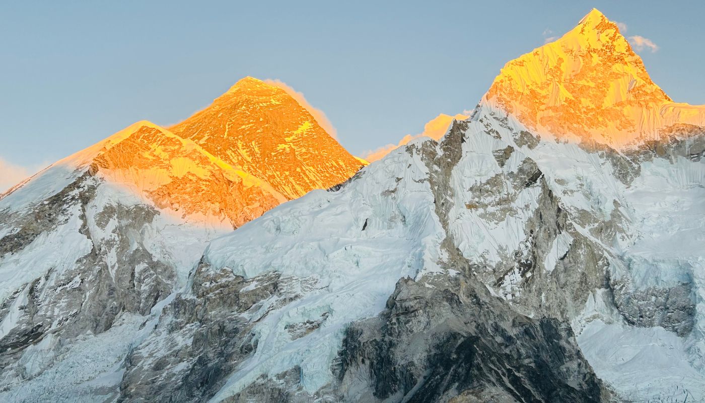
Gokyo Cho La pass trek also gives you close views of some of the tallest mountains in the world; that includes Cho Oyu (8201m), Makalu (8463m), Lhotse (8516 m), Everest (8850m) and more.
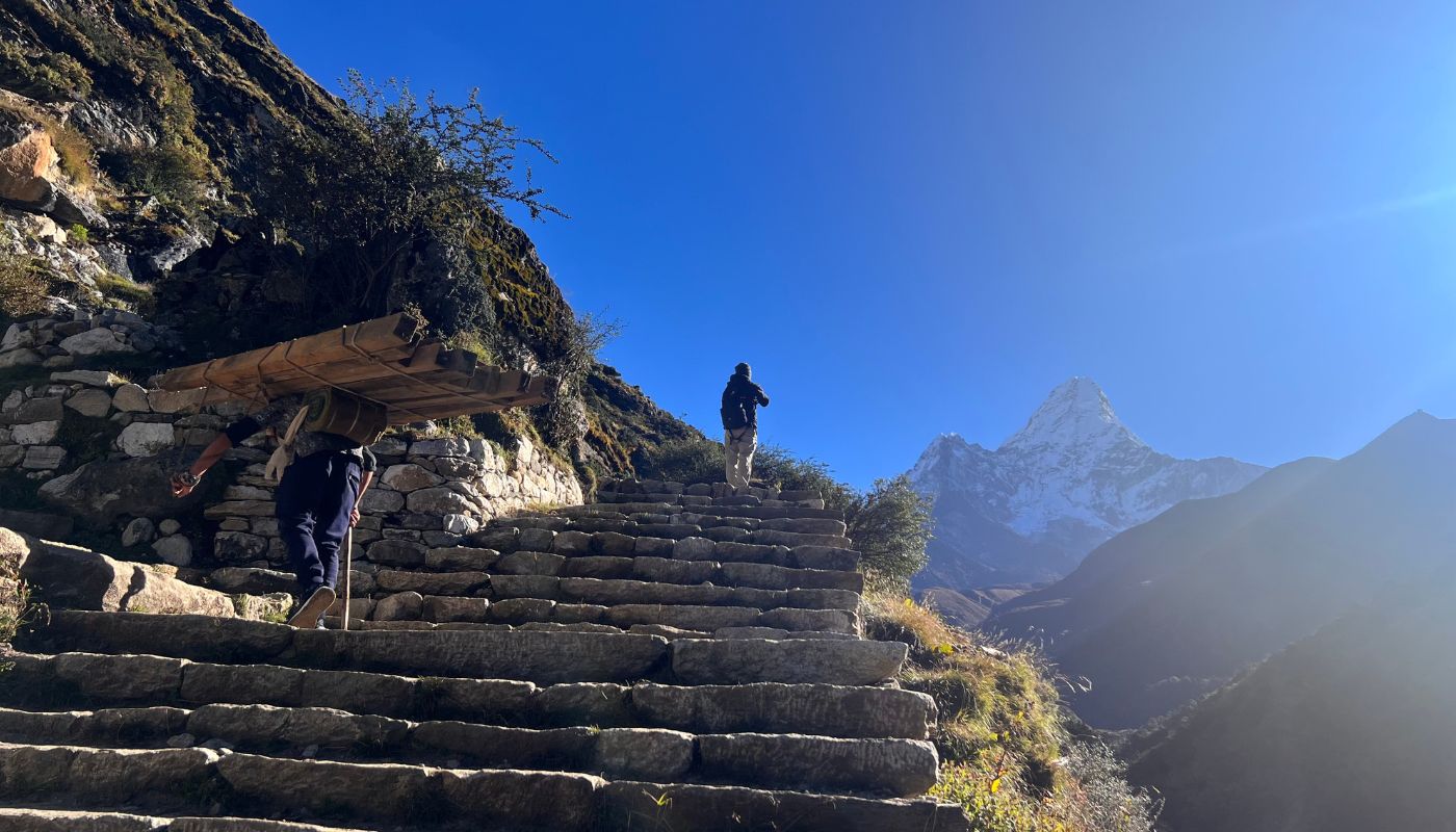
You will cross a mountain pass- Cho La pass (5420 meters)- along the way. The mountain pass is an excellent vantage point to view the mountains of the Everest region.
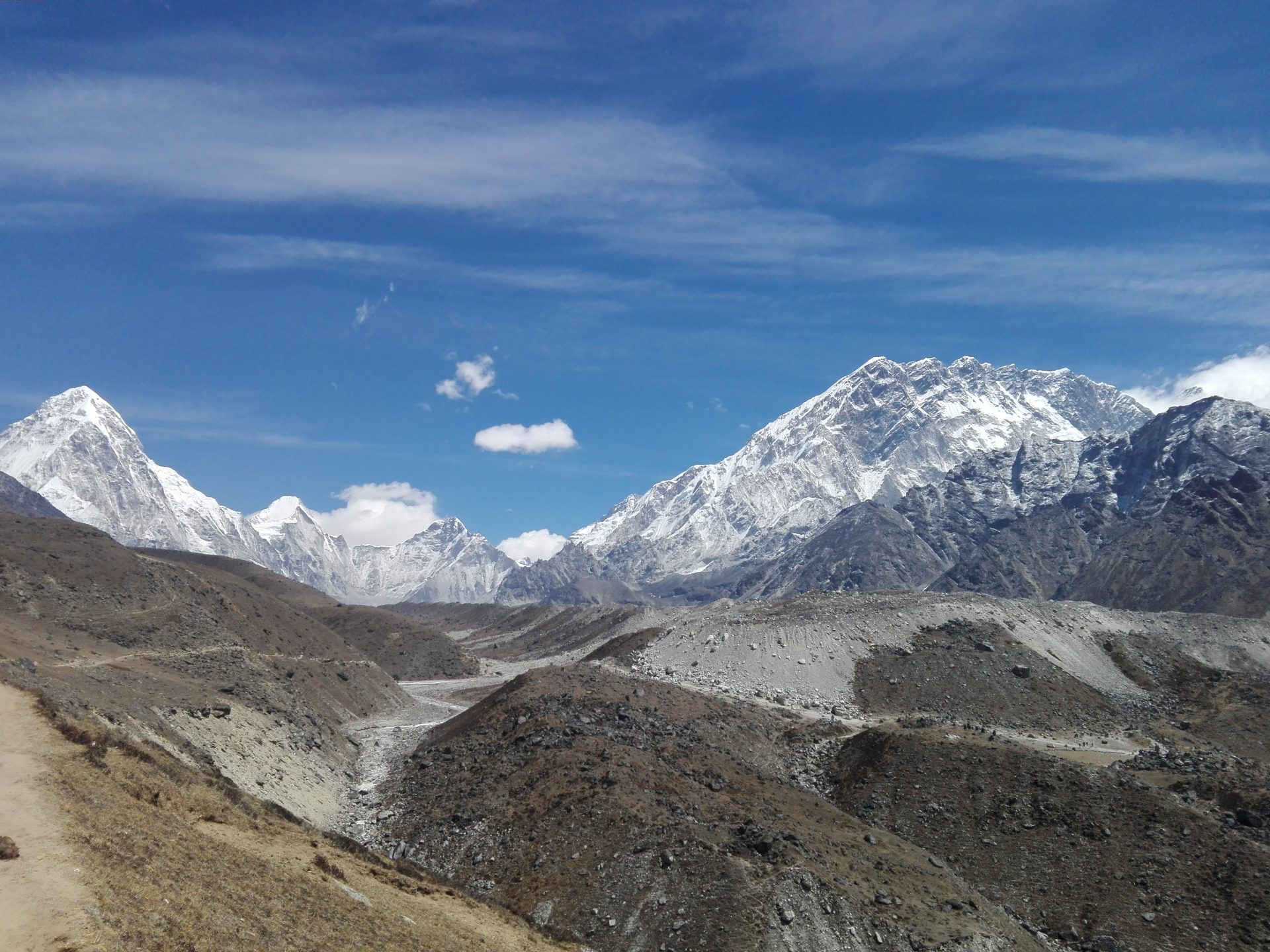
Besides these passes, you will also get some great views of glaciers and icefalls in this region. The Khumbu glacier, Ngozumpa glacier (the longest glacier in the Himalayas), and Cho La glacier are amongst the most popular glaciers in the Everest Region.
After you trek back from Everest Base Camp, you will head out to the gorgeous valley of Gokyo. This settlement is home to Gokyo Lakes, which are the highest freshwater lake system in the world. Gokyo Ri, which is a small mountain, which gives you spectacular sunrise amidst the mountains in the Everest region.
Learn the awesome culture of the Everest region as you enter Tengboche village. This is the largest monastery here, which provides shelter to hundreds of Buddhists monks.
Everest Cho La pass trekking is a small part of thrilling Everest High Passes Trek. Thus, it is the ultimate trekking destination for everyone; who are looking for the mesmeric beauty of everything the Everest region has to offer to travelers here.
Highlights
- UNESCO World Heritage Sites in Kathmandu.
- 35-minute flight over the Himalayas of the Everest region.
- Mesmerizing views of sunrise from Kala Patthar and Gokyo Ri.
- Visit the Gokyo lakes, which are the highest freshwater lake system in the world.
- Visit the largest monastery in the Everest region- Tengboche Monastery.
- Close views of various mountains like Everest, Lhotse, Makalu, Ama Dablam, Cho Oyu, Nuptse, Tawache and others
- A trek inside Sagarmatha National Park- a UNESCO Natural Heritage Site
- Cross Cho La pass
- Picturesque villages along the way.
- Hospitable and friendly locals in the Everest region.
Day 01: Arrive in Kathmandu (1,400 m/4,593 ft)
Transfer from Tribhuvan International Airport to your hotel in Thamel or a nearby district. Afterward, use the afternoon to rest or explore the city’s markets and temples. In the evening, your trek leader will conduct a pre-departure briefing, covering logistics, permits, and gear checks.
- Activities: Airport transfer, pre-trek briefing
- Max Altitude: 1,400 m
 Airport pickup on arrival
Accomodation: Hotel in kathamndu
Duration: 30 min drive
Distance: 8 KM drive
Fly to Lukla (2,840 m/9,317 ft) and trek to Phakding (2,610 m/8,563 ft)
The morning flight from Kathmandu offers views of the Himalayan range. Then, it lands at Tenzing-Hillary Airport. From Lukla, you’ll descend through terraced fields and pine forests to the Dudh Koshi River. Along the way, the trail passes small settlements and mani walls. Eventually, it reaches Phakding, a riverside village with basic teahouses.
- Activities: Scenic flight to Lukla, trek from Lukla to Phakding
- Max Altitude: 2,840 m
Land at Lukla airport
Accomodation: Lodge
Duration: 2-3 hour
Meal: Breakfast. Lunch, and dinner
Ascent: 1460 M/ 4710 ft.
Descent: -230 M/755 ft
Distance: 8 KM walk
Trek (3,440 m/11,286 ft) from Phakding to Namche Bazaar
Today’s trek from Phakding to Namche Bazaar covers 10-12 km over 5-6 hours. It takes you deeper into the landscapes along the Everest Base Camp trek. You’ll ascend along the Dudh Koshi River through rhododendron forests. Meanwhile, you’ll cross suspension bridges to reach the Sagarmatha National Park entrance, a UNESCO World Heritage Site.
Subsequently, the trail steepens with switchbacks. It offers your first stunning views of Mount Everest, Nuptse, Lhotse, and Taweche Peak. You’ll arrive at Namche Bazaar, often called the gateway to the Everest region of Nepal. It’s a vibrant village nestled in a horseshoe-shaped valley.
Finally, you’ll settle into a welcoming guesthouse. These are surrounded by colourful lodges and markets, soaking in the energy of this key stop on the trek route.
- Activities: Enter Sagarmatha National Park, trek from Phakding to Namche.
- Max Altitude: 3,440 m
Accomodation: lodge
Duration: 5-6 hrs walk
Meal: Breakfast, Lunch, Dinner
Ascent: +830 m/2,723 ft
Distance: 10 KM
Acclimatisation day in Namche Bazaar
Spend the day adjusting to altitude with a short hike to Everest View Hotel (3,880 m) or the villages of Khumjung and Khunde. Both routes offer clear mountain views and opportunities to visit local monasteries. Consequently, return to Namche by mid-afternoon and rest. Proper adjustment reduces the risk of altitude sickness on higher sections of the trek.
- Activities: Acclimatisation trek to Khumjung or the Everest View Hotel
- Max Altitude: 3,880 m
Accomodation: lodge
Duration: 4-5 hrs walk
Meal: Breakfast, Lunch, Dinner
Ascent: +440 m/1,444 ft (hiking up and returning to Namche)
Descent: -440 m/1,444 ft
Distance: 4 KM
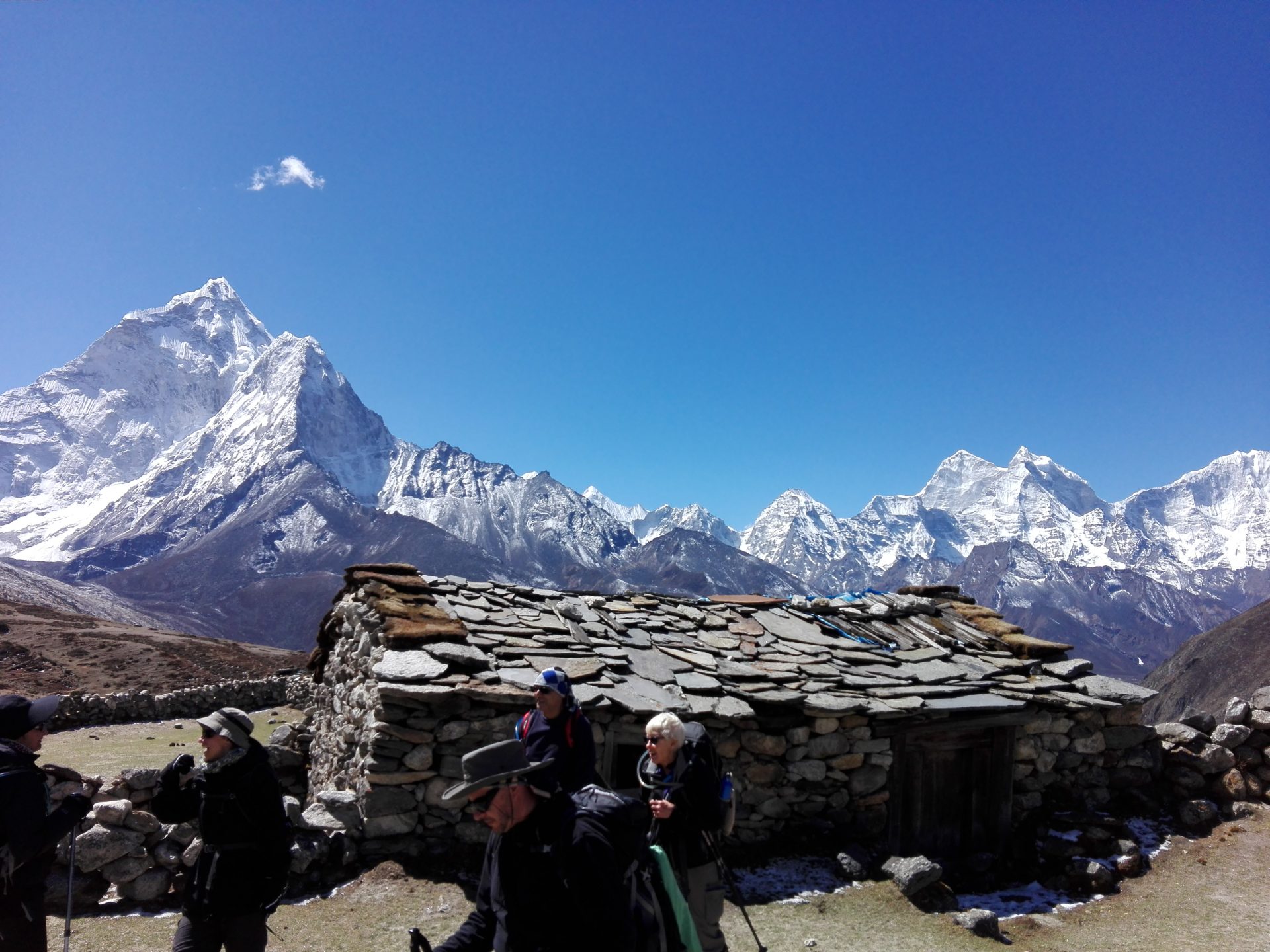
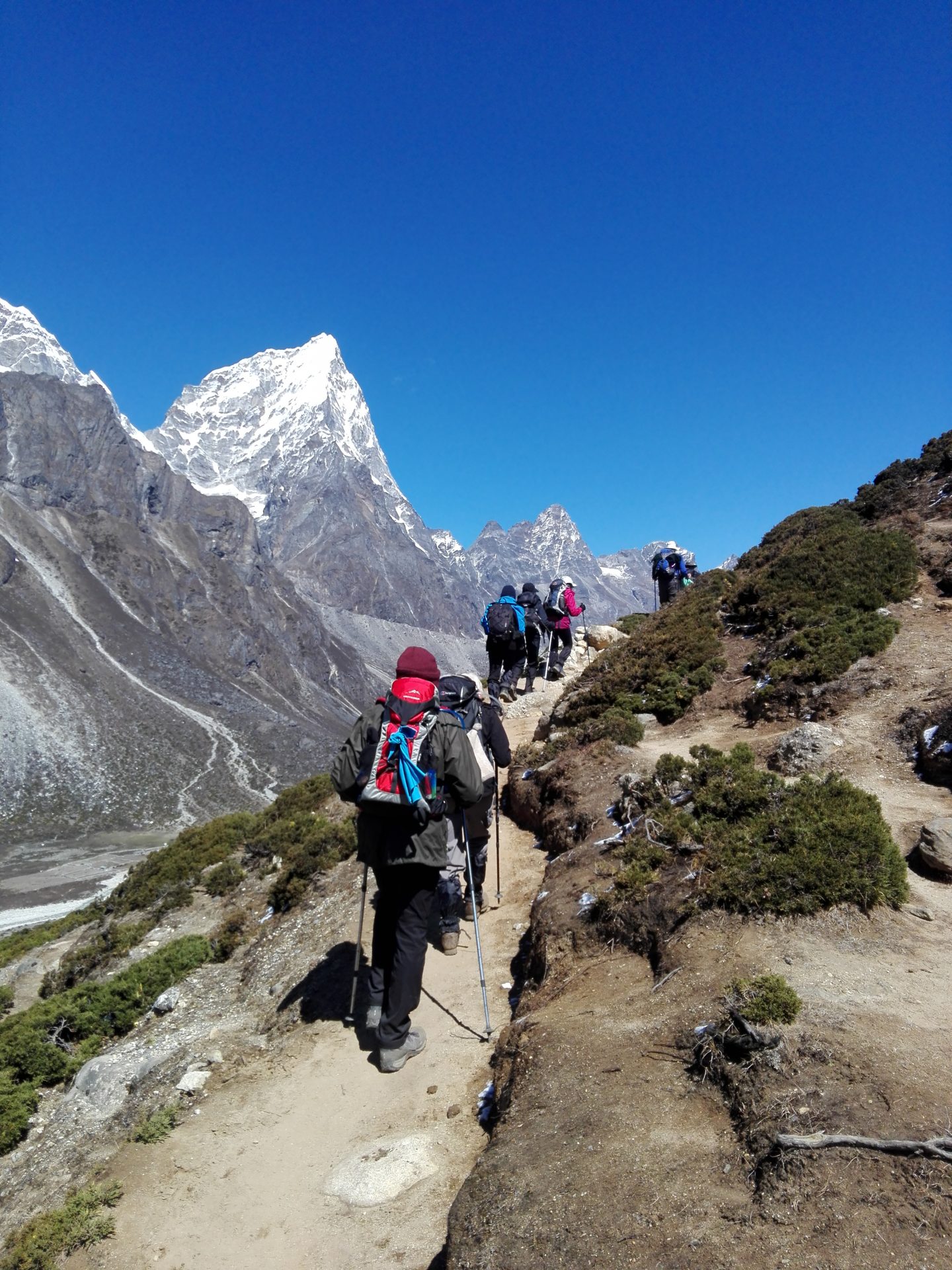
Trek from Namche Bazaar to Tengboche Monastery (3,860 m/12,664 ft)
Leave Namche and descend to the Dudh Koshi River. Cross the suspension bridge at Phunki Tenga, then begin a steep climb through rhododendron and pine forest. The path winds upward for several hours. Eventually, it emerges at Tengboche, home to the largest monastery in the Khumbu region. The monastery sits on a ridge with clear views of Everest, Lhotse, and Ama Dablam. Afternoon prayers may be attended if timing allows.
- Activities: Trek from Namche to Tengboche via forested paths
- Max Altitude: 3,860 m
Accomodation: lodge
Duration: 5 hrs walk
Meal: Breakfast, Lunch, Dinner
Ascent: +660 m/2,165 ft
Distance: 9 KM
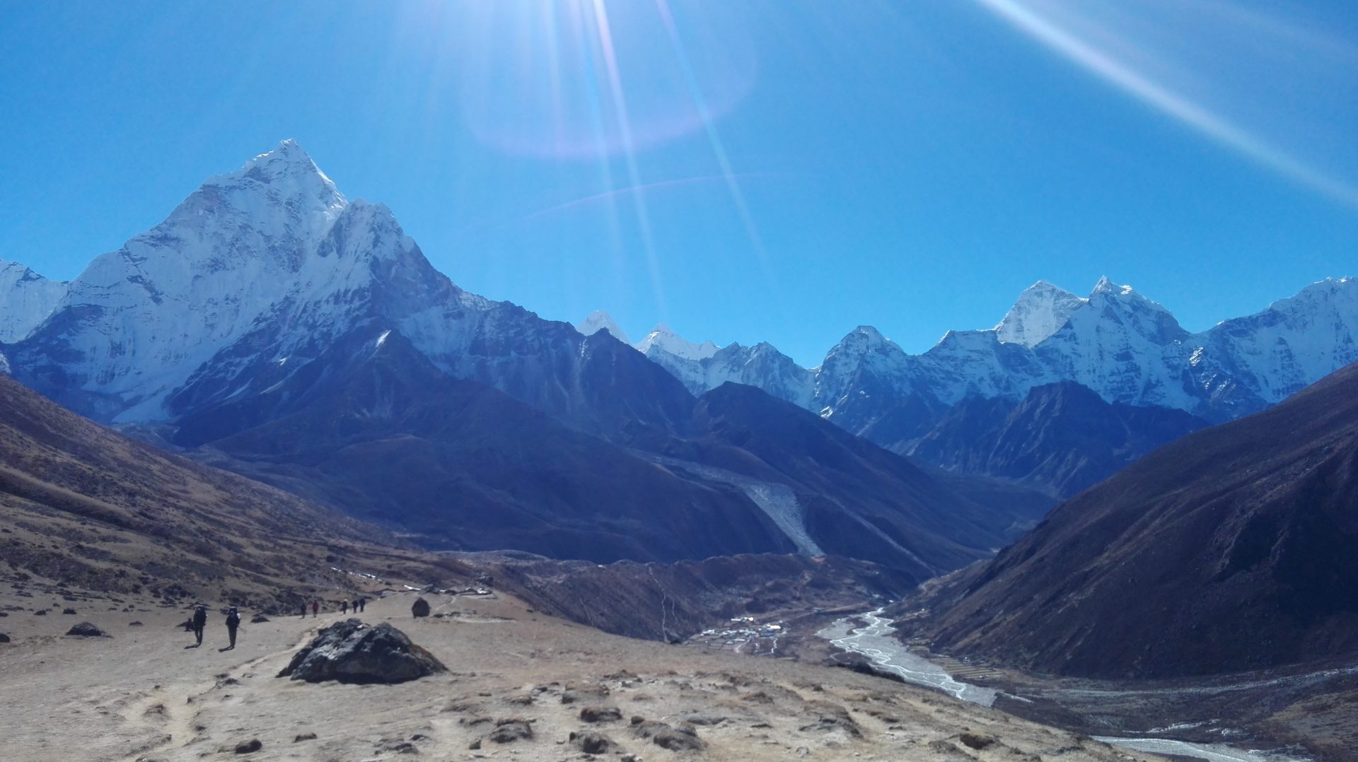
Trek from Tengboche to Dingboche (4,350 m/14,271 ft)
Descend through birch forest to the Imja Khola River. Cross the bridge and continue along the valley floor. The trail passes through Pangboche, the highest permanent settlement in the valley. Vegetation becomes sparse as altitude increases. The path then climbs steadily to Dingboche, a summer grazing settlement with stone-walled fields. Views of Island Peak and Lhotse dominate the southern skyline.
- Activities: Trek from Tengboche to Dingboche through river valleys
- Max Altitude: 4,350 m
Accomodation: lodge
Duration: 5-6 hrs walk
Meal: Breakfast, Lunch, Dinner
Ascent: +490 m/1,607 ft
Distance: 11 KM
Rest at Dingboche
Spend the day acclimatising at Dingboche. A short hike to Nagarjun Hill or Chhukung Ri provides additional elevation gain without the burden of a full pack. These excursions offer panoramic views of Makalu, Lhotse, and Ama Dablam. Return to the lodge for rest. Hydration and light meals help prepare the body for higher altitudes ahead. The village is quiet, with few distractions beyond mountain scenery.
- Activities: Acclimatization day with optional short hikes
- Max Altitude: 4,350 m (or higher on optional hikes)
Accomodation: lodge
Duration: 2-3 hour hike
Meal: Breakfast, Lunch, Dinner
Ascent: +400 M
Descent: -400 M
Distance: 4-5 KM
Trek to Lobuche (4,910 m/16,109 ft) from Dingboche
Climb gradually past the summer settlement of Dughla. The trail then ascends steeply to a ridge marked by stone memorials honouring climbers lost on Everest. Pause here briefly before continuing along the lateral moraine of the Khumbu Glacier. The landscape is barren, with glacial debris and scattered boulders. Lobuche consists of several lodges offering basic shelter. Temperatures are cold, particularly after sunset.
- Activities: Trek from Dingboche to Lobuche via Dughla.
- Max Altitude: 4,910 m
Accomodation: lodge
Duration: 5 hrs walk
Meal: Breakfast, Lunch, Dinner
Ascent: +560 m/1,837 ft
Distance: 7 KM
Trek to Everest Base Camp (5,365 m/17,598 ft), return to Gorak Shep (5,180 m/16,995 ft)
Leave Lobuche early and trek to Gorak Shep, the last settlement before base camp. Drop unnecessary gear at the lodge, then continue across the Khumbu Glacier. The route follows rocky moraines and glacial ice. Prayer flags mark Everest Base Camp, a temporary settlement during climbing season. Views are limited by surrounding peaks, but the location itself holds significance.
After spending time at base camp, retrace the route to Gorak Shep. The return involves careful navigation across uneven terrain. Arrive at Gorak Shep in the late afternoon. Rest and prepare for an early start the next morning.
- Activities: Trek to Everest Base Camp and return to Gorak Shep
- Max Altitude: 5,365 m
Accomodation: lodge
Duration: 7-8 hours
Meal: Breakfast, Lunch, and Dinner
Ascent: + 455 m/1,493 ft
Descent: -185 M / 606 ft
Distance: 12 KM
Hike up to Kala Patthar (5545 meters) and trek back to Dzongla (4620m.)
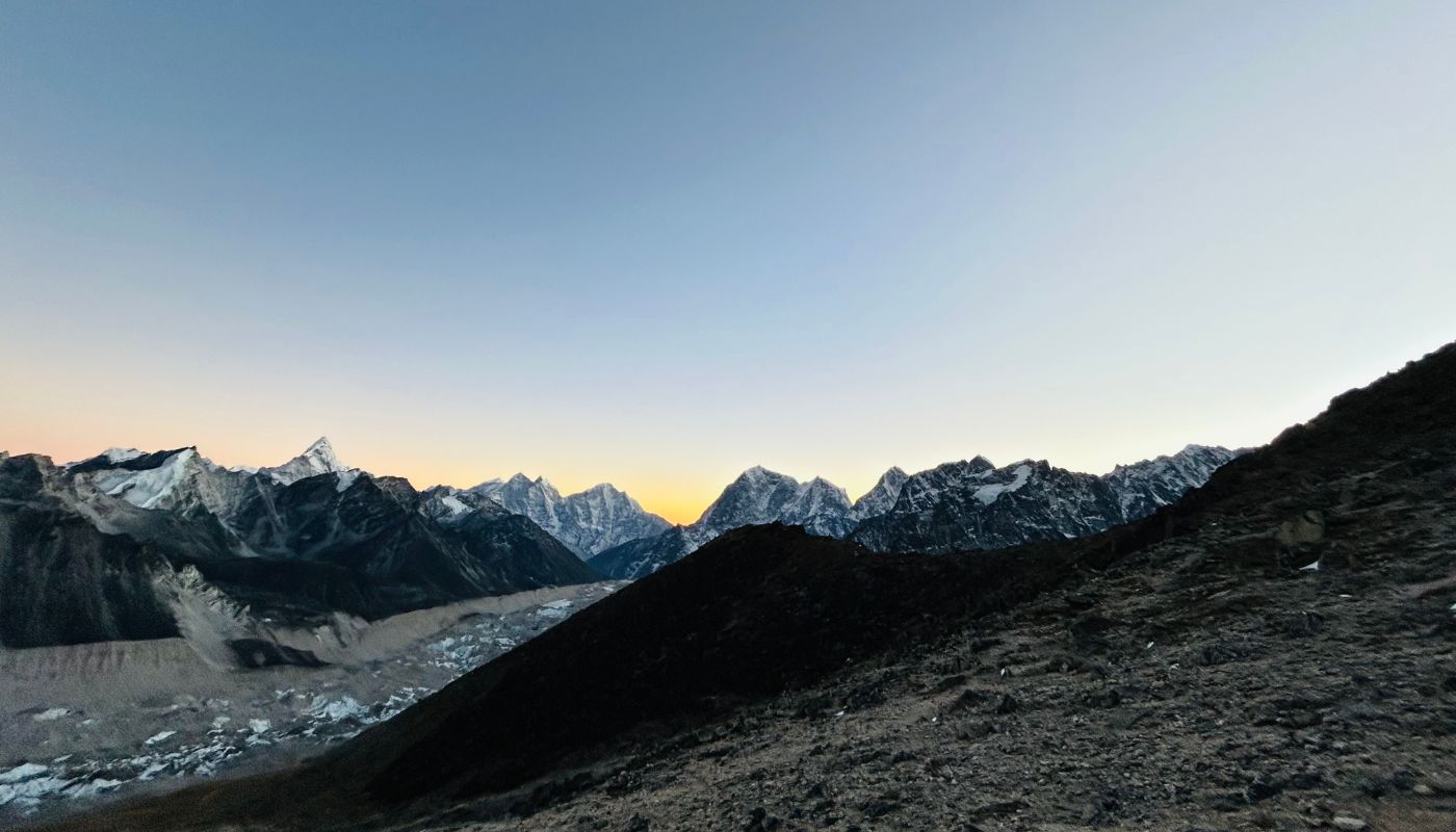
Rise before dawn for the ascent of Kala Patthar. The steep path climbs through darkness. Headlamps illuminate loose scree underfoot. Reach the summit as daylight spreads across the Himalayas. Everest, Nuptse, and Pumori stand in full view. The sunrise casts sharp shadows across glaciers and rock faces. Kala Patthar offers the clearest ground-level perspective of Everest’s summit.
Descend to Gorak Shep for breakfast. Pack up and begin the long trek west to Dzongla. The route crosses rocky terrain and follows lateral moraines. Dzongla sits beneath Cholatse peak, a small cluster of lodges used mainly by trekkers heading to Cho La Pass. The day is long and demanding.
- Activities: Summit Kala Patthar, trek to Dzongla
- Max Altitude: 5,545 m
Accomodation: lodge
Duration: 6-7 hour walk
Meal: Breakfast, Lunch, Dinner
Ascent: +365 M
Descent: -925 M
Distance: 10 KM
Trek from Dzongla to Thangna (4,650 m/15,256 ft)
Leave Dzongla and follow the trail west toward the Ngozumpa Glacier. The path crosses rocky terrain and passes through high-altitude meadows. Views of Cholatse and Taboche dominate the landscape. The route is relatively level compared to previous days, allowing a steady pace. Thangna is a small settlement with basic lodges near the glacier’s edge. The area is quiet and exposed to wind.
- Activities: Trek from Dzongla to Thangna along glacier route
- Max Altitude: 4,650 m
Accomodation: lodge
Duration: 4-5 hrs walk
Meal: Breakfast, Lunch, Dinner
Descent: -30 m/98 ft
Distance: 6 KM
Trek from Thangna to Gokyo (4,750 m/15,584 ft)
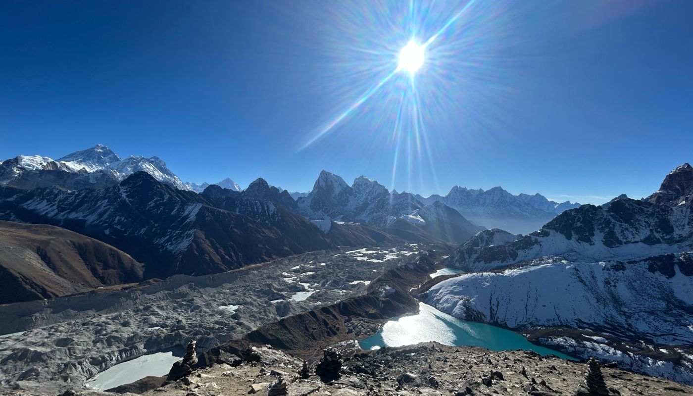
Proceed beside Nepal’s longest glacier, Ngozumpa. Pass the first and second Gokyo Lakes, their turquoise water contrasting with grey rock and white ice. Cross a small ridge and descend to the third lake. The serene Gokyo village stands on the eastern shore. The settlement is basic but well-positioned for viewing Cho Oyu and the surrounding peaks. Afternoon light reflects off the lake surface.
- Activities: Trek from Thangna to Gokyo, explore Gokyo Lakes
- Max Altitude: 4,750 m
Accomodation: lodge
Duration: 3-4 hrs walk
Meal: Breakfast, Lunch, Dinner
Ascent: +766 M
Descent: - 666 M
Distance: 5-6 KM
Climb Gokyo Ri (5,483 m/17,989 ft), trek to Machhermo (4,410 m/14,469 ft)
Rise early for the pre-dawn ascent of Gokyo Ri. The steep path zigzags up scree and rock to a small summit marked by prayer flags. From the top, impressive sunrise views of Everest, Lhotse, Makalu, and Cho Oyu form a continuous wall of summits. The view from Gokyo Ri is particularly breathtaking. Meanwhile, the Ngozumpa Glacier stretches below like a frozen river.
Descend to Gokyo for breakfast. Pack up and begin the long trek down to Machhermo. The descent follows the same route taken earlier, passing the Gokyo Lakes and crossing alpine meadows. Machhermo sits in a wide valley. The drop in altitude provides noticeable relief.
- Activities: Summit Gokyo Ri at sunrise, descend to Machhermo
- Max Altitude: 5,483 m
Accomodation: lodge
Duration: 7-8 hrs walk
Meal: Breakfast, Lunch, Dinner
Ascent: 733 m/2,405 ft,
Descent: 1,073 m/3,520 ft
Distance: 12 KM
Trek from Machhermo to Namche Bazaar (3,440 m/11,286 ft)
Retrace the route down through Dole and along the Dudh Koshi Valley. The path descends through rhododendron forest and crosses several suspension bridges. Pass Phortse Tenga and continue the steady descent. Rejoin the main Everest Base Camp trail before reaching Namche. The town’s amenities, including bakeries, hot showers, and stable internet, feel luxurious after days at higher elevations.
- Activities: Descend through Dole to Namche Bazaar..
- Max Altitude: 4,410 m
Accomodation: lodge
Duration: 6-7 hrs walk
Meal: Breakfast, Lunch, Dinner
Descent: -970 m/3,182 ft.
Distance: 15 KM
Trek from Namche Bazaar to Lukla (2,840 m/9,317 ft)
Follow the Dudh Koshi downstream, retracing the first day’s route in reverse. Pass through Phakding and several smaller settlements. The trail crosses multiple suspension bridges and winds through pine forest. Make the final climb to Lukla. The town is busy with trekkers completing or beginning their journeys. Celebrate the completion of your trek with your guide and porters over a group meal.
- Activities: Trek from Namche to Lukla, celebration dinner
- Max Altitude: 3,440 m
Accomodation: lodge
Meal: Breakfast, Lunch, Dinner
Descent: -600 m/1,969 ft
Distance: 6-7 hrs walk
Fly to Kathmandu and transfer to hotel
Weather permitting, catch an early morning flight back to Kathmandu. The return flight is often smoother than the outbound journey. Transfer to your hotel and spend the remainder of the day resting. You can also shop for souvenirs or explore areas of the city you missed on arrival. The scenic flight offers final views of the mountains.
- Activities: Scenic flight to Kathmandu, hotel transfer
- Max Altitude: 2,840 m
Accomodation: Hotel
Duration: 30 minutes and drive to hotel
Meal: Breakfast
Descent: -1440 M
Distance: -------------
Departure
Transfer to Tribhuvan International Airport for your onwards flight. Depending on departure time, you may have a few hours for last-minute shopping or sightseeing in Kathmandu.(by paying extra) Visit local markets or take a final walk through Thamel if time allows.
- Activities: Airport transfer for international departure
Accomodation: Hotel
Duration: 30 Min Drive
Meal: Breakfast
Distance: 8 KM drive to airport
Cost Includes
- Arrival & Departure Transport By private Car/Van/Bus.
- Three meals a day during the Trekking (B, L,D)
- Accommodation in Tea House during the Trekking.
- Two night Accommodation in Kathmandu with B/B Plan.
- Trekking Guide and a proter (Sharing by two clients) with Insurance, food, accommodations and all their needs
- Flight ticket for guide Kathamandu/Lukla/Kathmandu
- Flight ticket for Clients Kathmandu/Lukla/Kathmandu
- First Aid kit.
- Trekking permit (Conservation fee).
- Tims card (Trekking information management system) as like a permit.
- Free Company’s duffel bag.
- Trekking Map.
- All needed official fees and taxes.
Add-ons and Options(not included)
- Extra porter in mountain: $350 per porter
- Single room supplement charge: $500 per person
- Kathmandu to Lukla helicopter flight: $600 per person (one way)
- Hotel upgrade in Kathmandu: Depends on hotel category
- Extra night accommodation in mountain: $150 per day per person
Cost Excludes
- International Airfare.
- Your travel insurance.
- Nepal Visa fee
- Any kind of drinks.
- Items of personal expenses like hot shower, battery charge, telephone, Extra Porters etc.
- Tips for Guide and Porters.
Temperature Chart
Altitude Chart
Useful Info
Best Time & Weather Conditions
The Everest Cho La Pass Trek is best undertaken during spring (March to May) and autumn (September to November). These windows offer stable weather, clear skies, and manageable temperatures during the trekking season. Indeed, the best time for Everest Chola Pass adventures ensures your safety and enjoyment.
Seasonal Comparison
Spring (March to May)
Spring brings warmer days and blooming rhododendrons at lower elevations. Morning temperatures at Gokyo range from -5°C to 5°C, while afternoons reach 10°C to 15°C. Cho La Pass may still hold snow from winter, requiring additional caution. Visibility is excellent, though afternoon cloud build-up is common. This season offers warmer temperatures and rhododendron forests in full bloom, making it highly recommended for most trekkers.
Autumn (September to November)
Autumn provides the clearest skies of the year. Temperatures are slightly cooler than spring, with nights dropping to -10°C at high camps. The post-monsoon atmosphere is crisp, and mountain views are consistently sharp. This is the most popular trekking season, offering the best visibility all year and stable weather conditions. Teahouses fill quickly during this period, so advance booking is advised.
Winter (December to February)
Winter is possible for experienced trekkers but presents significant challenges. Cho La Pass becomes dangerously icy, and several high-altitude lodges close. Temperatures plummet to -20°C or lower at night. Lukla flights are more reliable than in other seasons, and there are fewer trekkers on the trail. This season is recommended only for those with extensive high-altitude and winter trekking experience.
Monsoon (June to August)
Monsoon season is not recommended. Heavy rain turns trails to mud at lower elevations, while clouds obscure mountain views. Lukla flights face frequent delays and cancellations. The Cho La Pass crossing is particularly hazardous due to snow and reduced visibility. Leeches are also common at lower elevations during this period.
Temperature Guide by Elevation
| Location | Altitude | Spring/Autumn Day | Spring/Autumn Night | Winter Night |
| Lukla | 2,840 m | 10°C to 15°C | 0°C to 5°C | -5°C to -10°C |
| Namche Bazaar | 3,440 m | 8°C to 12°C | -2°C to 3°C | -10°C to -15°C |
| Gokyo | 4,790 m | -5°C to 5°C | -10°C to -5°C | -20°C or lower |
| Cho La Pass | 5,420 m | -8°C to 0°C | -15°C to -10°C | -25°C or lower |
| Gorak Shep | 5,164 m | -5°C to 2°C | -12°C to -8°C | -22°C or lower |
Best Time Summary
- Optimal Seasons: Spring (March–May) and Autumn (September–November)
- Peak Months: October and April offer the best balance of weather stability, temperature, and visibility
- Avoid: Monsoon season (June–August) due to weather hazards and poor visibility
Permits, Logistics & Transportation
Required Permits
Sagarmatha National Park Entry Permit
- Cost: NPR 3,000 (approximately $23 USD)
- Issued at Nepal Tourism Board office in Kathmandu or park entry gate in Monjo
- Bring passport and two passport-sized photographs
Khumbu Pasang Lhamu Rural Municipality Permit
- Cost: NPR 3,000 (approximately $23 USD)
- Obtained in Lukla or arranged by your trekking company in advance
- Required for all trekkers entering Khumbu region
Your trekking company typically arranges both permits before departure. Carry photocopies, as checkpoints along the route require permit verification.
Transport Options
Kathmandu to Lukla Flight
The standard route is a 30-minute flight from Tribhuvan International Airport to Tenzing-Hillary Airport in Lukla. Flights operate from early morning and are subject to weather delays. During peak season (October–November, April–May), flights may depart from Ramechhap Airport. This is a four to five-hour drive east of Kathmandu. It reduces congestion and improves schedule reliability.
Alternative Overland Route
If flights are unavailable, drive to Phaplu or Salleri. Then, begin trekking from there. This adds 2 to 3 days to the trek itinerary but eliminates flight dependency. Moreover, the lower-altitude start also aids getting used to altitude.
Contingency Planning
Lukla flights are notoriously unpredictable. Weather can ground planes for days, particularly during monsoon and winter. Build at least two buffer days into your schedule – one before the trek and one after. Travel insurance should cover trip delays and cancellations.
Preparation & Training
Fitness Plan
The Chola Pass trek demands strong heart fitness and leg strength. Begin training three to four months before departure. Focus on:
- Aerobic base: Run, cycle, or swim four to five times weekly for 45 to 60 minutes
- Hill training: Hike with a weighted pack (10 kg) on steep terrain. Simulate trekking days with six to eight-hour outings
- Strength work: Incorporate squats, lunges, and step-ups twice weekly to build leg and core stability
- Altitude simulation: If accessible, train at altitude or use an altitude training mask for adjustment advantages
Consistency matters more than intensity. Build gradually to avoid injury and allow your body to adapt to sustained effort.
Gear & Packing List
Clothing
- Base layers (merino wool or synthetic)
- Insulating mid-layers (fleece or down jacket)
- Waterproof and windproof outer shell
- Trekking trousers (quick-dry fabric)
- Warm hat, sun hat, and buff or scarf
- Gloves (liner and insulated pair)
- Thermal underwear for high camps
Footwear
- Broken-in trekking boots (ankle support, waterproof)
- Microspikes or crampons for Cho La Pass
- Camp shoes or sandals for evenings
Equipment
- Sleeping bag rated to -10°C or colder
- Trekking poles (adjustable, with snow baskets)
- Headlamp with spare batteries
- Sunglasses (UV protection, Category 4)
- Water bottles or hydration bladder (3 liters capacity)
- Stuff sacks for organizing gear
Accessories
- Sunscreen (SPF 50+) and lip balm
- Personal first aid kit
- Water purification tablets or filter
- Toiletries and quick-dry towel
- Trekking map and compass or GPS device
Insurance & Medical Readiness
Travel Insurance Requirements
Purchase comprehensive travel insurance covering:
- Helicopter rescue from altitudes up to 6,000 meters
- Medical treatment and hospitalisation
- Trip cancellation and interruption
- Lost or stolen gear
Policies must explicitly state coverage for trekking above 5,000 metres. Verify that Cho La Pass (5,420 m) falls within the policy’s altitude limit.
Medical Preparation
Consult your doctor before departure. Discuss altitude sickness prevention and carry prescribed medications such as acetazolamide (Diamox). Update routine vaccinations. Consider shots for hepatitis A, typhoid, and rabies. Pack a personal medical kit with blister treatments, painkillers, antibiotics, and rehydration salts.
Route, Map & Elevation Profile
Elevation Chart
[Placeholder for elevation chart image to be inserted later]
Map & Route Overview
[Placeholder for map and route overview image to be inserted later]
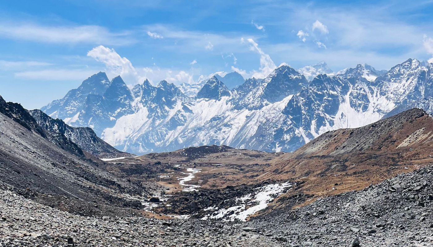
The Everest Base Camp Cho La Pass trek follows a clockwise circuit through the heart of the Everest region. Beginning at Lukla (2,840 m), the route ascends the Dudh Koshi Valley to Namche Bazaar (3,440 m). Then, it diverges west towards the Gokyo Valley. Gradual elevation gain continues through Dole (4,200 m), Machhermo (4,470 m), and Gokyo (4,790 m).
After the ascent of Gokyo Ri (5,357 m), trekkers cross the high-altitude crossing of the Cho La Pass (5,420 m). This is the technical high point throughout the trek. The route then joins the standard Everest Base Camp trek trail at Dzongla (4,620 m). It continues through Lobuche (4,940 m) and Gorak Shep (5,164 m).
Side trips include Everest Base Camp (5,364 m) and Kala Patthar (5,545 m), the maximum altitude. The Everest Base Camp route provides access to these iconic destinations.
Descent follows the Khumbu Valley through Pheriche (4,371 m) and Namche Bazaar before returning to Lukla. Total distance covered is approximately 130 kilometres with over 8,000 metres of total elevation gain. The Everest Base Camp via Gokyo route offers a complete experience of the region.
Key Elevation Points
- Lukla: 2,840 m
- Namche Bazaar: 3,440 m
- Gokyo: 4,790 m
- Gokyo Ri: 5,357 m
- Cho La Pass: 5,420 m
- Kala Patthar: 5,545 m (highest point)
- Everest Base Camp: 5,364 m
Terrain Characteristics
In the lower sections below 3,500 m, the trail winds through dense forests, suspension bridges, and cultivated terraces. Then, as you climb higher, the middle elevations between 3,500 and 4,500 m gradually open into alpine meadows and scattered boulder fields. Beyond this, the high-altitude zones above 4,500 m present glacial moraine, exposed rock, and stretches of permanent snow. For example, trekkers face the challenge of Cho La Pass, which involves scrambling over ice-covered boulders and crossing short snow slopes.
Accommodation, Food & Water
Teahouse Accommodation
Teahouses are family-run lodges providing basic sleeping rooms and communal dining areas. Rooms contain twin beds with foam mattresses, pillows, and blankets. Walls are thin, and insulation is minimal. Therefore, expect cold nights at higher elevations. Bathrooms are shared, with squat or Western-style toilets. Hot showers cost extra and may be unavailable above 4,500 metres.
Namche Bazaar and Lukla offer the most developed facilities. These include heated dining rooms, bakeries, and internet access. Mid-elevation lodges in Dole and Machhermo provide adequate comfort with limited amenities. High camps like Gorak Shep and Dzongla are basic, with unheated rooms and simple meals during the trek.
Food on the Trail
Teahouse menus feature a mix of Nepali, Tibetan, and Western dishes. For instance, common options include dal bhat (rice and lentils), fried noodles, momos (dumplings), soups, and pasta. In addition, breakfast choices include porridge, pancakes, eggs, and toast. Moreover, meals are calorie-dense to support the energy demands of trekking.
Food quality is generally good in lower villages but becomes simpler at altitude. Fresh vegetables and meat are scarce above Namche. Portions are generous, and vegetarian options are widely available. Carry snacks such as energy bars, nuts, and chocolate for trail consumption.
Water Safety
Do not drink untreated water from taps or streams. Purchase bottled water, though plastic waste is a growing environmental concern. Most lodges provide boiled water for a small fee. Fill your bottles each morning. Alternatively, use water purification tablets or a portable filter to treat water from natural sources.
Dehydration speeds up altitude sickness. Therefore, aim for three to four liters of fluid daily. Herbal tea and electrolyte drinks supplement water intake.
Health, Safety & Altitude Strategy
Altitude Sickness
Acute Mountain Sickness (AMS) results from rapid ascent to high altitude. As a result, symptoms can include headache, nausea, dizziness, fatigue, and loss of appetite. In most cases, mild AMS affects trekkers at some point. However, it usually resolves with rest and proper hydration.
Severe forms – High Altitude Pulmonary Edema (HAPE) and High Altitude Cerebral Edema (HACE) – are life-threatening. HAPE symptoms include breathlessness at rest, coughing, and chest tightness. HACE presents as confusion, loss of coordination, and severe headache. Both conditions require immediate descent and medical attention.
Prevention Strategies
- Ascend slowly. Follow the itinerary’s adjustment schedule
- Stay hydrated. Drink three to four liters of water daily
- Avoid alcohol and sleeping tablets at altitude
- Eat regular meals even if appetite decreases
- Consider acetazolamide (Diamox) to aid adjustment. Consult your doctor before use
What to Do If Symptoms Appear
Stop ascending. Rest for 24 to 48 hours at the current altitude. If symptoms worsen or do not improve, descend immediately. Your guide will assess your condition and arrange evacuation if necessary.
Emergency Protocols
Guides carry first aid kits and oxygen cylinders for emergencies. Portable altitude chambers (Gamow bags) may be available for stabilising patients before descent. Communication with lodges and rescue services occurs via satellite phone or radio.
Helicopter evacuation is the fastest rescue method. Depending on the weather, choppers can reach most trekking areas within hours. Evacuation costs range from $3,000 to $10,000. These are covered by travel insurance if policy terms are met. Inform your guide immediately if you feel unwell. Early intervention prevents problems.
Medical Supplies
Carry a personal first aid kit containing:
- Blister treatment (Compeed, moleskin)
- Pain relief (ibuprofen, paracetamol)
- Altitude sickness medication (Diamox, dexamethasone)
- Antibiotics for stomach upset (ciprofloxacin)
- Rehydration salts (ORS)
- Bandages, antiseptic wipes, and medical tape
- Personal prescription medications
Guides carry additional supplies. However, self-sufficiency reduces delays in treatment.
Culture, Villages & Local Life
Sherpa Heritage
The Khumbu region is home to the Sherpa people, an ethnic group with Tibetan roots. Centuries ago, Sherpas moved to Nepal, settling in high valleys and gradually adapting to life above 3,000 metres. Over time, their culture blended Tibetan Buddhism with mountain traditions, creating a distinct identity centred on resilience, hospitality, and spiritual practice.
In Sherpa villages, stone houses feature carved wooden windows, while prayer wheels stand at entrances. Additionally, colourful prayer flags stretch across rooftops. Moreover, monasteries anchor community life, serving as centres for religious ceremonies and festivals. Trekkers are welcome to observe prayers; however, they should always ask permission before photographing monks or interiors.
Throughout your journey in the Everest region, you will witness this living culture firsthand. Indeed, each village along the Everest Base Camp and Cho La Pass route tells a story of adaptation and survival in one of Earth’s harshest environments.
Key Villages
Namche Bazaar
The region’s unofficial capital, Namche, is a bustling market town built into a horseshoe-shaped hillside. Here, shops sell trekking gear, handicrafts, and fresh produce. In addition, the Sherpa Culture Museum offers insight into local history and mountaineering achievements. On Saturdays, the weekly market attracts traders from surrounding valleys. Overall, this vibrant hub serves as the cultural and commercial heart of the Base Camp Chola Pass trek.
Lukla
The gateway to the Khumbu, Lukla sits at 2,840 metres where most treks begin and end. The town clusters around Tenzing-Hillary Airport, one of the world’s most challenging landing strips. Lodges, bakeries, and gear shops line the main street. Despite its small size, Lukla buzzes with nervous energy as trekkers prepare for departure or celebrate their return.
Dingboche
Located at 4,410 metres in a wide valley, Dingboche serves as a crucial adjustment stop. Here, stone walls protect barley fields from wind and livestock. From this vantage point, the village offers clear views of Lhotse, Island Peak, and the dramatic north face of Ama Dablam. Moreover, lodges are well-equipped to support altitude adjustment, with heated dining rooms and medical facilities conveniently nearby.
Tengboche
Perched at 3,860 metres, Tengboche Monastery overlooks the Dudh Koshi Valley, with Everest visible in the distance. Established in 1916, it is the Khumbu’s most significant monastery. Visitors can attend morning and evening prayers, accompanied by chanting and ceremonial horns. Additionally, the monastery’s courtyard offers unobstructed views of Ama Dablam.
Lobuche
At 4,940 metres, Lobuche consists of a handful of basic lodges serving trekkers bound for Everest Base Camp. The settlement sits below the Khumbu Glacier in a barren, rocky landscape. Temperatures drop sharply at night, and facilities are minimal. Memorial cairns for fallen climbers line the trail just before the village, serving as sobering reminders of the mountain’s power.
Gokyo
This small settlement beside the third serene Gokyo Lake serves trekkers heading to Gokyo Ri or Cho La Pass. Lodges are basic but comfortable. The setting – turquoise water framed by Cho Oyu – is among Nepal’s most photogenic. The village is quieter than those on the main EBC route.
Cultural Etiquette
- Walk clockwise around chortens, mani walls, and monasteries
- Remove shoes before entering homes and religious sites
- Avoid pointing feet towards people or sacred objects
- Ask permission before photographing individuals, especially monks
- Dress modestly. Shorts and sleeveless tops are unsuitable in villages
- Decline offers to purchase religious artifacts, which may be culturally unsuitable to sell
Photography & Viewpoint Guide
Top Viewpoints
Gokyo Ri (5,357 m)
The sunrise climb to Gokyo Ri delivers 360-degree views of Everest, Lhotse, Makalu, and Cho Oyu – four of the world’s six highest peaks. The turquoise Gokyo Lakes contrast with the grey Ngozumpa Glacier below. Arrive at the summit before 7 AM for optimal light. Use a wide-angle lens to capture the full panorama. The view from Gokyo Ri is unforgettable.
Kala Patthar (5,545 m)
Kala Patthar offers the closest ground-level views of Mt Everest’s southwest face. Nuptse and Pumori frame the scene. Dawn light illuminates the peaks in shades of gold and pink. A telephoto lens (70–200 mm) isolates Everest’s summit pyramid. Expect sub-zero temperatures. Therefore, protect camera batteries in inner pockets.
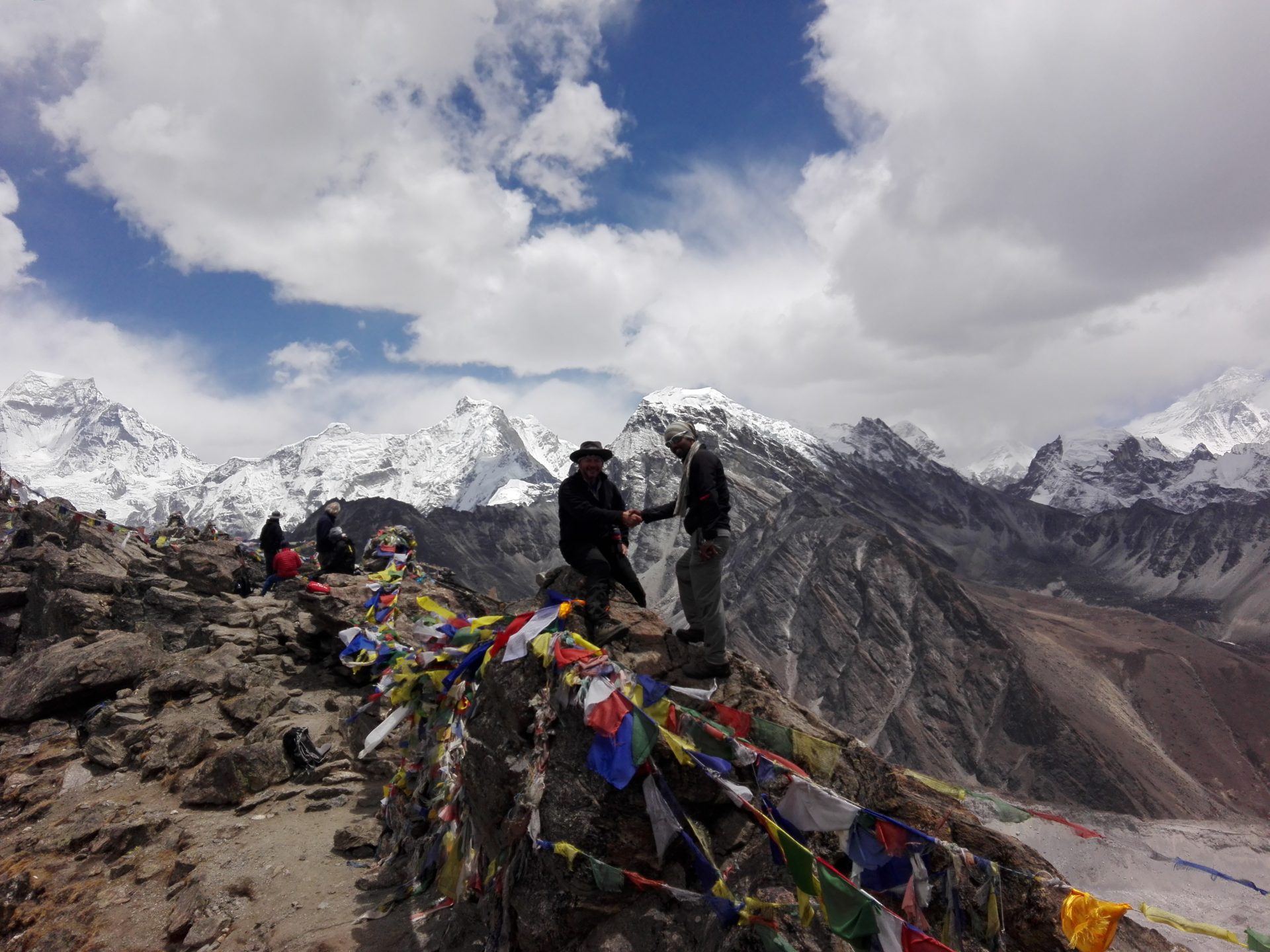
Cho La Pass (5,420 m)
The pass itself is dramatic, with prayer flags fluttering against a backdrop of ice-streaked cliffs. From here, photograph from the eastern side of the pass looking west towards Cholatse and Ama Dablam. At midday, light reduces contrast on the glaciers. Therefore, use a polarising filter to deepen blue skies and reduce snow glare.
Ngozumpa Glacier
The world’s longest Himalayan glacier stretches for 36 kilometres. Along the route, walk along its lateral moraine between Machhermo and Gokyo for close-up shots of crevasses, ice towers, and meltwater pools. In the late afternoon, light enhances texture and shadow.
Photography Tips
- Protect gear from cold. Batteries drain quickly in freezing temperatures. Carry spares in warm pockets
- Use UV or polarizing filters to reduce haze and enhance contrast
- Shoot in RAW format for greater post-processing flexibility
- Capture local life respectfully. Portraits require permission and build rapport before asking
- Include foreground elements (prayer flags, trekkers, yaks) to add depth and scale to mountain shots
Tips & Advice for Success
Pacing and Acclimatisation
Walk slowly, especially above 4,000 metres. The phrase “pole pole” (Swahili for “slowly slowly”) applies here. Rest frequently. Do not rush to reach the day’s destination. Proper pacing reduces fatigue and lowers altitude sickness risk.
Take adjustment days seriously. Even if you feel strong, resist the urge to skip rest days or speed up the itinerary. Your body needs time to produce more red blood cells. This helps it adjust to lower oxygen levels.
Weather Preparedness
Mountain weather changes rapidly. Carry waterproof layers even on clear days. Mornings are typically calm. Then, clouds build after midday. Plan demanding sections (Cho La Pass, Gokyo Ri, Kala Patthar) for early morning when visibility is best.
Cold is the primary challenge above 5,000 metres. Temperatures drop to -15°C or lower at night. Layer clothing and keep extremities warm. Frostbite can occur within minutes on exposed skin during windy conditions.
Environmental Responsibility
The Khumbu’s fragile ecosystem faces pressure from increased trekking traffic. Follow Leave No Trace principles:
- Carry out all non-biodegradable waste. Pack used batteries, wrappers, and toiletries
- Use designated toilets. If none are available, bury waste at least 50 meters from water sources
- Reduce plastic use. Refill water bottles rather than purchasing new ones
- Stay on marked trails to prevent erosion
- Do not disturb wildlife or remove plants
- Support lodges that use solar power and manage waste responsibly
Interaction with Porters and Guides
Treat your guide and porter with respect. They work in harsh conditions and carry loads that exceed international labour standards. Ensure your porter has adequate clothing and footwear. If you notice they are struggling, reduce the load or hire an additional porter.
Tipping is customary but not mandatory. This depends on group size and trek length. Tips are best given at the completion of your trek in a group envelope.
Staying Healthy
- Wash hands frequently, especially before meals. Carry hand sanitiser
- Avoid raw vegetables and unpeeled fruit at high altitude
- Brush teeth with bottled or boiled water
- Get adequate sleep. Rest speeds up adjustment
- Monitor your body. Persistent headaches, dizziness, or nausea warrant immediate action
After the Trek & Next Steps
Recovery in Kathmandu
Spend one to two days in Kathmandu. This allows your body to recover. For accommodation, book a hotel with hot showers and comfortable beds. Additionally, consider a massage to ease muscle soreness accumulated over 17 days of trekking. While in the city, explore the restaurants and sample Nepali cuisine beyond dal bhat.
Visit sites you missed before the trek. Pashupatinath Temple, Boudhanath Stupa, and Patan Durbar Square offer cultural immersion without physical demands. Shop for souvenirs in Thamel’s markets. You can find thangka paintings, singing bowls, and handmade textiles.
Sharing Your Experience
Document your journey through photographs and journal entries. Additionally, share responsibly on social media. Moreover, credit guides and porters by name (with their permission). Finally, consider writing a review for your trekking company. Detailed feedback helps future trekkers make informed decisions.
If you encountered exceptional service or challenges, communicate directly with the company. Constructive reviews improve industry standards. They also support ethical operators.
Comparing Related Treks
Renjo La Pass Alternative
Some trekkers choose the Renjo La route instead of Cho La Pass. The Renjo La Pass (5,360 m) connects Gokyo Valley with Thame. It offers different mountain views. However, it’s less technical than Cho La Pass. The Everest Chola Pass route provides more direct access to Everest Base Camp.
Three Pass Trek
For those seeking another trek challenge, the Three Pass Trek combines Renjo La, Cho La Pass, and Kongma La. This creates a complete circuit of the Everest region. The trek takes approximately 19-21 days. It’s more demanding than the standard Everest Chola Pass Trek.
Classic Everest Base Camp Route
The classic Everest Base Camp route follows a direct path from Lukla to Everest Base Camp and back. It skips the Gokyo Valley entirely. This version takes 12-14 days. It’s less challenging than the Everest Base Camp via Gokyo option.
The Everest Chola Pass Trek combines the best of both routes. Trekking to the Everest region via Cho La Pass provides complete valley coverage.
Trek with Experience, Return with Stories
The Everest Cho La Pass Trek 17 days stands among Nepal’s most rewarding alpine journeys, combining the classic Everest Base Camp experience with the remote beauty of the Gokyo trek. This 17-day adventure demands strong physical fitness, mental endurance, and respect for high-altitude conditions. In return, it offers unmatched Himalayan views and deep immersion in Sherpa culture, making it one of the most complete trekking experiences in the Everest region. Furthermore, this trek is an adventurous journey that challenges and rewards in equal measure.
From the serene turquoise Gokyo Lakes to the icy challenge of Cho La Pass, the route captures the full range of the Khumbu’s character. Trekkers encounter glacial moraines, rhododendron forests, windswept passes, and prayer-flag-draped summits that have long connected mountain communities and ancient trade paths. Each step reveals the region’s spiritual and natural harmony, where the quiet strength of the Himalaya meets the warm hospitality of the Sherpa people. Indeed, this trek is an adventurous experience throughout the entire Everest region.
At Nepal Hiking Adventure Co., we guide this trek with experienced Sherpa-led teams who focus on safety, adjustment, and environmental care. Our Everest Cho La Pass Trek itinerary balances adventure with proper rest, ensuring trekkers stay healthy and fulfilled throughout. Whether you seek personal achievement, photographic inspiration, or a genuine cultural connection, this journey delivers. Moreover, this Base Camp Chola Pass trek is a perfect blend of challenge and beauty. Join us and book your Everest Cho La Pass Trek today to experience the Khumbu at its most breathtaking and memorable.
Contact us today to plan your trek, customise your route, or speak directly with our Himalayan trekking experts for personalised guidance before your journey.
FAQ
Is Everest Chola Pass trek too difficult or even dangerous?
The answer to this question is Yes and no. Yes; because altitude might kill some people so care must be taken to acclimatize properly. No; from the lack of so-called “objective” danger like rockfall or crevasses normally associated with the climbing. However, people have been seriously injured by the yaks who happened to bump them off the trail and down a steep hillside. So always be on the uphill side when a yak moves by.
Does the trek require any kind of training?
Yes. This trek requires a certain level of fitness. If you’re not already following the fitness regime, you also would need to follow the full routine and that is shared here with you. The training routine is also spread with over four months and you would also be expected to work out at least 4 times a day.
The regime is also designed and to help you climb smarter even at the higher altitudes. The regime consists of a good combination of exercises which works at the parts of your body including – Upper Body, Core, Endurance, Lower Body, Shoulder strength, and streamlining your breathing ways. When followed dutifully you can rest assured that you will be ready for the trek.
Is there a full proof diet plan that we should follow to train for EBC?
Eating right amounts that amounts to 70 percent of the effort you put will be getting you going. The nutritious diet can also aid the body sustained the pressure which will be going during the trek and also at the workouts. You can also consult your trek captain too.
What kind of weather can I expect during trekking? How cold does it get?
The temperatures in September could be in the range from 28° to – 10°, depending at the altitude. Make sure you stay warm and dry in all times.
Are your staff equipped/trained and insured?
Yes! Our guides and porters are fully trained, equipped, and also provided for. Our Trek Captain comes with the experience of doing at the the EBC trek priorly. Every member in a trekking group work as also well oiled team and take care of each other’s responsibility to it’s fullest.
How difficult is the Everest Cho La Pass Trek compared to the standard EBC route?
The Everest Cho La Pass Trek is more demanding and technical than the standard Everest Base Camp trek. It involves steep ascents, high-altitude crossings, and glacial terrain, requiring solid fitness and prior Himalayan trekking experience. Indeed, this pass trek is an adventurous undertaking that tests your endurance.
What are conditions like on Cho La Pass, and when is it safest to cross?
Cho La Pass is a challenging high-mountain crossing with icy trails and unpredictable weather. The best time to cross Cho La Pass is in spring (March–May) or autumn (September–November) when the snow is firm and skies are clear, ensuring safer passage with crampons or microspikes.
What fitness level do I need, and how should I train?
Trekkers need excellent stamina and heart endurance for this high-altitude adventure. Train for at least three months with hill walking, leg-strength workouts, and long hikes to prepare for 6–8 hours of trekking above 4,000 metres each day.
How much weight can porters carry, and what should I keep in my daypack?
Porters on the Everest Cho La Pass Trek usually carry 20–25 kg shared between two trekkers. Keep essentials like water, snacks, warm layers, sunscreen, and a first aid kit in your personal daypack, as porters often arrive later at the lodge.
What happens if Lukla flights are cancelled?
Flight delays to and from Lukla are common due to weather conditions in the Himalayas. Include buffer days in your itinerary or opt for a helicopter flight to Kathmandu if cancellations extend; travel insurance should cover such disruptions.
Can I complete this trek independently without a guide?
Is altitude sickness a serious concern on this trek?
Yes, altitude sickness (AMS) is a major concern on the Everest Cho La Pass route. Proper adjustment in Namche Bazaar and Gokyo, slow ascent, and guidance from experienced Sherpas help reduce risks of HAPE or HACE.
Independent trekking is allowed but not advised on the Everest Cho La Pass route. Guides from Nepal Hiking Adventure Co. ensure safety, manage altitude, and navigate the glacier sections, making your journey smoother and more secure.
What type of travel insurance do I need?
You need comprehensive travel insurance covering helicopter evacuation up to 6,000 metres. Confirm it includes high-altitude trekking, medical coverage, and trip cancellation protection before starting your Everest Cho La Pass adventure.
Reviews
wonderful experience with NHA
I had a wonderful experience while trekking to Everest Chola Pass Trek, Our team especially the porters and guide were extremely helpful and always had a smile on their faces. They were also well-equipped and knew all the nooks and corners of Everest. Will be coming in the time and budget adjusts to be willing.
Brown,
USA
Great guide for the trek
I went to Nepal from Apr.6~Apr.24,and had an awesome experience about “GOKYO, EBC trekking. “Nepal Hiking Adventure Company provide complete travel plan including airport pick-up service, city guide-tour in Kathmandu, and the most important of all, I’m satisfied with the guide Ram .He offered me a safe trek and shared the culture of Himalaya.
Caleb Nelson,
USA
Great trekking guide and poter- plus good arrange
I and my partner had many email exchanged for months with Bishnu before our trekking to EBC & Chola Pass (Apr. 17~ May 3rd, 2016). Bishnu also came to our Kathmandu hotel several times to explain the details. During the trekking, our guide Rudra took care of me and my partner (had high altitude sickness) very thoughtful. Our porter is a very gentile young man. He also help us scrambled up to Chola Pass (17,782 ft. higher than EBC and much difficult).
Bishnu also arranged my trip to Pokhara very well (I just gave him two days advance notice that I would take that trip)
It was a great experience!
Kent
Victoria Perez,
Australia
Everest Base Camp and Gokyo lake and Cho la pass, 9 friends, 17 day trek
I was one of the nine from London UK on 10th May 2016 who completed the above trek with Nepal Hiking company.
I would like to add that this is a tough trek especially the Gokyo-Ri, but the views and cultural experience and hospitality will stay with me forever.
Bishnu, Ram and the team appeared to go the extra mile to make our trek run as smoothly as possible considering the difficulties of getting supply’s to such a high altitude. I was especially impressed when one of our team required hospital treatment for altitude related problems and this was handled professionally.
We all had a good time and I could recommend Nepal Hiking Company to whoever who is considering a challenging adventure of this nature.
Please understand that sometimes a open mind to the facilities is required. This all adds to the adventure.
Liam Martin,
UK
Everest base camp gokyo ri and chola pass awesome trip 11 days
They arranged a porter, TIMS card, Lukla Flight and permit for me and it was worth the money i spent. Everything was well organised and i didnt had any problem during my whole trek. I would recommend this agency especially Mr. Pratap rai ji who were our porter, he is 52 and a very wise man, and also Bishnu who is extremely humble and polite and owner of this agency. over all few of the best people i met.
Sameer Aggarwal,
Canada

Our History in Service Excellence